|
|

|
City of Boulder Storm Water Quality Program |
|
Boulder Creek Watershed
Water Quality Data Time Series for 2002
Boulder Creek at Eben G. Fine Park |
Preliminary Data - subject to revision
|
|
|
|
 Indicates no data available Indicates no data available |  Indicates data exceeds plot scale. Indicates data exceeds plot scale. |
|
|
|
|
Monitoring site information: |
|

|
- Location: Boulder Creek at Eben G. Fine Park
- Name: BC-EFP
- Type: Grab
- Frequency: Periodic
- Longitude: 105 ° W 18'
- Latitude: 40 ° N 59'
- Elevation: feet asl
- Site photo
|
|
|
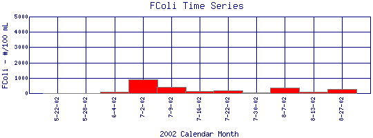
| Plot Label |
Date |
FColi
#/100 mL |
| 5-22-02 |
May 22, 2002 |
16* |
| 5-28-02 |
May 28, 2002 |
20 |
| 6-4-02 |
June 4, 2002 |
90 |
| 7-2-02 |
July 2, 2002 |
910 |
| 7-9-02 |
July 9, 2002 |
400 |
| 7-16-02 |
July 16, 2002 |
150 |
| 7-22-02 |
July 22, 2002 |
170 |
| 7-30-02 |
July 30, 2002 |
40 |
| 8-7-02 |
August 7, 2002 |
360 |
| 8-13-02 |
August 13, 2002 |
103 |
| 8-27-02 |
August 27, 2002 |
290 |
| * indicates measured value below analysis detection limit listed below: |
|---|
| Lower Detection Limit |
20.0 |
|---|
|
Preliminary Data - subject to revision
|
|
Select on the parameter name to view more detailed information on that parameter at this station.
Select on the table date to view stream data profiles observed on that date.
|
INVITATION:
BASIN is a community project actively seeking public participation. We
appreciate all feedback and welcome comments, suggestions and contributions.
To find out more about how you can be involved,
click here.
|
|
Home
| Site Map
| Glossary
| Bibliography
| Contributors
About BASIN
| Attribution
| Feedback
| Search
|
