BASIN-USGS-COB Boulder Creek Millenium Baseline
Boulder Creek Watershed
Total Dissolved Solids Data for 2000 - Boulder Creek at Dry Creek

Preliminary Data - subject to revision


Information on Total Dissolved Solids:

More general information about Total Dissolved Solids
Factors affecting Total Dissolved Solids
Standards regarding Total Dissolved Solids
Interpretation of Boulder Creek Total Dissolved Solids data
Data Source:
Point of Contact:
Collection and Analysis notes

Monitoring site information:
BC-aDC Map
  • Location: Boulder Creek at Dry Creek
  • Name: BC-aDC
  • Type: Composite
  • Frequency: SemiAnnual
  • Longitude: 105 ° W 85'
  • Latitude: 40 ° N 29'
  • Elevation: 5060 feet asl
  • Site photo
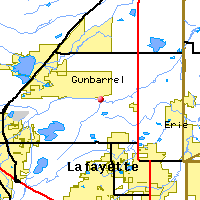
Downstream Site: Boulder Creek at 75th St
Upstream Site: Boulder Creek at 95th St

Date TDS
mg/L
June, 2000 34
October, 2000 332
*value below detection limit:
Detection Limit (if available) 1

Preliminary Data - subject to revision

Select on the parameter name to view all Total Dissolved Solids time series plots on the basin map. Select on the table date to view stream Total Dissolved Solids profiles observed on that date. Select here to view all parameters at this site.

Return to the BASIN water quality catalog

Return to the BASIN environmental data catalog


INVITATION BASIN is a community project actively seeking public participation. We appreciate all feedback and welcome comments, suggestions and contributions. To find out more about how you can be involved, click here.

BASIN is funded through the US EPA EMPACT Program

Home | Site Map | Glossary | Bibliography | Contributors
About BASIN | Attribution | Feedback | Search
Last Page Update - Tuesday December 27, 2005
IMS support provided by Enfo.com