Position paper and action request
March 17, 2006
Background
The administration, in connection with its 2007 budget, has proposed to fund an extension of this act by selling over 300,000 acres of public land. According to the Forest Service list, land proposed for sale in Colorado totals 21,572 acres. Notice of the proposal was published in the Federal Register on March 1, 2006, with a public comment period of 30 days ending March 30, 2006. The proposed parcels in Boulder County amount to between 1,800 acres and 2,900 acres, depending on which set of information from the Forest Service is used. The Boulder District Ranger puts the figure at 2,100 acres. PLAN-Boulder County's preliminary estimate is 2,200 acres.
Executive summary and recommendations
PLAN-Boulder County was founded on the principles of good land use planning and implementation and on vigorous public input and participation. This federal proposal dismally fails to meet any of those criteria. PLAN-Boulder County urges public officials and individual citizens to oppose this proposal as a whole and also to comment to the Forest Service in Washington, D.C., on the specific parcels as detailed in this PLAN-Boulder County position paper.
Comments should be submitted by March 30, 2006 by email, by fax to (202) 205-1604, or by mail to USDA Forest Service, SRS Comments, Lands 4S, 1400 Independence Ave. SW., Mailstop 1124, Washington, DC 20520-0003. Electronic submission is preferred.
Nearly all the parcels of U.S. Forest Service lands in Boulder County have been the subject of extensive planning at the federal and local level. Proposals for sale at this time have resulted primarily from bureaucratic analyses at the federal level, with no understanding of detailed land-use analysis or long-term planning history. Specifically, areas in the western United States that were important mining areas have many mining claims that subdivide federal lands, and the superficial designation of land for sale in 2007 has concentrated on areas like Boulder that have been active mining areas. Having contributed historically to federal mining revenue, Boulder is now being singled out for shortsighted sale of federal land. As a result the land proposed for sale in Boulder County is proportionally 10 times the average elsewhere in the western U.S.
Boulder County, which is the northeast terminus of the Colorado Mineral Belt, is the center of an important scattering of mining claims, so all federal lands in the county are fragmented with inholdings from the era of mining a century ago.
Federal agencies, including the Forest Service and the BLM have been successfully disposing of parcels that pose significant management problems through a process of trades with local jurisdictions, including the Boulder County/BLM/USFS trade. If any federal public lands are to be disposed of, it should be pursuant to well-thought-out plans that focus on trading lands with other public agencies, rather than proposals that put more public land into private ownership. Public lands should never be seen as a commodity that can be sold for purposes of revenue generation.
Proper management of this legacy requires enlightened planning. Boulder County has been in the forefront of dealing with this national legacy, along with local federal agencies, particularly the BLM and the Boulder District Office of the Forest Service. PLAN-Boulder County lauds their efforts and urges the citizens of the county and their elected officials to continue to support these long-term planning efforts and to oppose shortsighted disposal of public assets, of which the current proposal is a disastrous example.
Thank you for considering this important request.
Sincerely,
Pat Shanks, chair
PLAN-Boulder County Board
Background — Sale of Public Lands
The Forest Service is charged with sustainable management of public lands for the benefit of the public and of future generations. This land sale proposal was precipitously drafted to meet a budget goal to raise a specific amount of revenue. Proper management of the public trust was neither a goal nor a consideration of this proposal. Management of any long-term assets, and especially the public lands, can only be done by careful evaluation on the merits. Attempts to use public assets for short-term cash requirements are poor management and poor planning by definition. Boulder County Commissioner Will Toor succinctly described the process, "This is like selling your house to pay the credit card bill."
Specifically, the plans were drafted in Washington with minimal (and very hurried) input from local land managers. The primary criterion was that the sales raise $800 million. The basis for parcel selection was to pick tracts separated from other land, but the individuals who made the designation did so with no knowledge about local planning that had already been done, nor about joint management agreements made with other government entities, such as Boulder County. As the specific comments below indicate, nearly all the parcels in Boulder County have problems due to lack of attention to detail and to elementary planning principles. Many parcels are wildlife migration corridors or are contiguous to county or other preserved open space.
PLAN-Boulder County has supported sale and trade of Forest Service and BLM lands in many instances, when those transfers make sense. For example, the program of conveying BLM land to Boulder County in exchange for Boulder County conveying Forest Service inholdings to the Forest Service has been a model of good stewardship and land management.
More generally, selling off capital assets, not because they have been judged to be superfluous, but to meet short-term cash needs, is always a sign of bad management and lack of planning. In government, program budgets have to be funded through sustainable income streams, not by selling off assets with no thought to their continuing value. This proposal is the result of political expediency, not good stewardship or budgetary responsibility.
Process
The one-size-fits-all, made-in-Washington, D.C., method of selection of parcels, together with a very short comment period, and minimal and deceptive information on the specifics, all combine to provide an archetype of bad planning.
Public comment on this very complicated package of public lands was limited to 30 days. Not only has the Forest Service not provided maps, the District Ranger's Office has been specifically directed by the Agriculture Department not to provide maps. This is a clear subversion of the process for public input. The website to which the public was directed was not even functioning on the date that the parcels were announced. It is still exceedingly slow, because the Internet server was not sized to handle the traffic, and several functions on the site still do not work at all.
Many of the maps from the USFS online system are inaccurate, as the Forest Service admits. The boundaries shown for the parcels in Left Hand Canyon, for example, are not correct.
Most of the parcels proposed for sale in Boulder County have always been federal lands, so they have never been accurately surveyed. The cost of surveying some of these parcels, doing impact studies and providing appropriate legal descriptions is likely to cost more than the revenue that might be anticipated from sale. Some parcels do not have access rights that could be transferred to a private purchaser. In selecting the parcels, no consideration was given to the cost of the proposed sales. It is quite likely that the federal revenue anticipated is unrealistic because of this poor planning, and the additional costs passed to the local level will be very high.
Finally, no consideration has been given to the planning already invested in these parcels. Some specific instances are described below, but given the process that has been followed, many more consequences can be expected that cannot be determined during the artificially short comment period. Some of the private land shown as fragmenting the parcels actually consists of conservation land or easements specifically purchased by the Nature Conservancy and Colorado Open Lands to eliminate management problems and expense for the Forest Service. In other words, the lands proposed for sale are not really expensive, hard-to-manage areas. Some may fit this description, but none of the bureaucrats who picked the parcels have bothered to verify their choices. We know that many of the parcels do not fit this description at all.
It seems obvious that the process that has been unveiled is designed not to obtain public input and consider it, but to avoid public input and to guarantee that it will be of poor quality. The officials responsible for the process are acting against the public interest and are violating their official obligations. They are being paid high salaries and are using them to defraud the public.
Specific Parcels Proposed for Sale in Boulder County
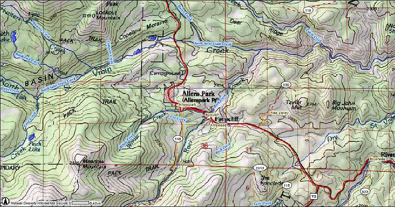
Allenspark area:
Roosevelt National Forest
Township 2N Range 72W
Section 20 — 40 acres
Section 21 — 40 acres
Section 29 — 40 acres
Section 30 — 40 acres
The parcels are on both sides of the Peak-to-Peak Scenic Byway, and should be managed as they have been. They should not be sold and opened up for commercial or residential development.
Map (crosshatched areas proposed for sale)
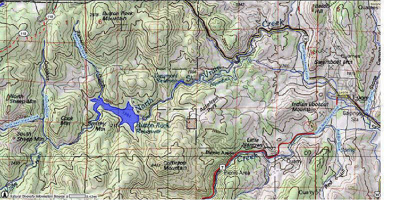
Button Rock Reservoir/North St. Vrain area:
Roosevelt National Forest
Township 3N Range 71W
Section 21 — 40 acres
Total: 40 acres
This small parcel is adjacent to the Hall Ranch Boulder County Open Space and the city of Longmont Button Rock Reserve, and it should be managed for preservation. It is also an important watershed for the city of Longmont.
Map (crosshatched areas proposed for sale)
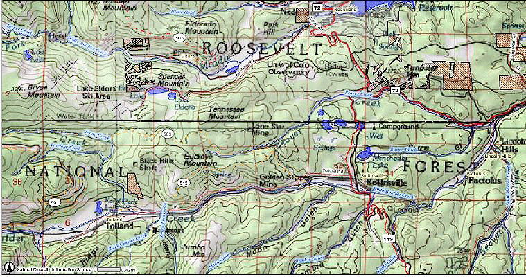
Eldora area:
Roosevelt National Forest
Township 1S Range 73W
Section 20 — 20 acres according to document — appear to be 5-8 times that large
These parcels are part of one of the major entrances to the Indian Peaks Wilderness, a critical area for preservation. Note that this area has been a major planning area between the town of Eldora, the Forest Service and Boulder County. It is a sensitive wildlife, environmental, and access area, and these parcels are critical to the agreed objectives. Sale of these parcels would reverse years of planning and management.
Map (crosshatched areas proposed for sale)
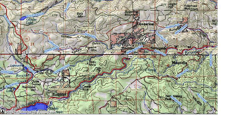
Boulder Canyon near Sugarloaf Road:
Roosevelt National Forest
Township 1N Range 72W
Section 25 — 120 acres
Section 35 — 240 acres
Section 36 — 240 acres
Township 1N Range 71W
Section 29 — 120 acres
These parcels include significant acreage on both sides of the canyon, particularly to the north. Most segments are designated to be preserved in the Boulder County Comprehensive Plan. The largest parcels are designated as part of the Boulder Falls Natural Area, and portions are part of a potential nesting area for golden eagles. A portion of this area has been designated as a black bear concentration area by the Colorado Division of Wildlife. This area should be managed for preservation. It has no place in a list of properties that should be sold.
Map (crosshatched areas proposed for sale)
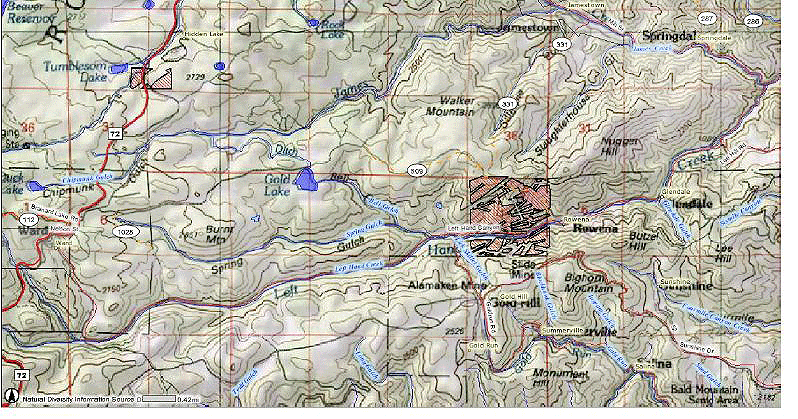
Left Hand Canyon area:
Roosevelt National Forest
Township 1N Range 72W
Section 1 — 240 acres
The Forest Service maps show parcels on both the north and south of the canyon. The largest area is in Section 1, on the north side of the canyon. The map is misleading, showing Forest Service property on the north side that occupies most of the section, but that is highly fragmented because of mining claims. In fact, Boulder County has purchased nearly all of these inholdings, and the area is designated as part of the Walker Mountain Environmental Conservation Area in the Boulder Valley Comprehensive Plan. All the parcels on both sides of the canyon in this area should be preserved, in keeping with long-standing land-use planning at both local and Federal levels.
Map (crosshatched areas proposed for sale)
Caribou Ranch area:
Roosevelt National Forest
Township 1N Range 73W
Section 34 — 30 acres
Section 36 — 80 acres
Township 1S Range 73W
Section 1 — 20 acres
Two parcels shown abut the Caribou Ranch Open Space that has been purchased by Boulder County for preservation. One also abuts the Peak-to-Peak Scenic Byway, and the other is part of its backdrop. These parcels should be managed for their scenic and environmental values, as long recognized in local and federal planning.
Map (crosshatched areas proposed for sale)
Magnolia Road-Winiger Ridge Area:
Roosevelt National Forest
Township 1S Range 72W
Section 19 — 40 acres
Section 20 — 193 acres
Section 21 — 160 acres
Section 14 — 40 acres
The proposed parcels are part of a major wildlife migration corridor, as well as being critical development buffers and geological landmark areas. (Winiger Ridge is a Miocene paleovalley.) The Colorado Division of wildlife has mapped these parcels as important elk winter concentration range and as an elk migration corridor. They are designated as important wildlife preservation areas in the Boulder Valley Comprehensive Plan. Several of the parcels are adjacent to either USFS or Boulder County open space.
Map (crosshatched areas proposed for sale)
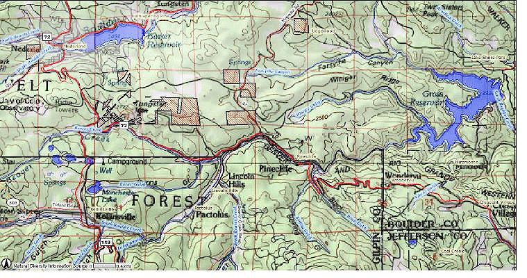
Tungsten Area (Ridge Road, north of Boulder Canyon and Barker Reservoir):
Roosevelt National Forest
Township 1S Range 72W
Section 5 — 117 acres
Section 8 — 160 acres
The parcel shown just north of Boulder Canyon is adjacent to the Boulder County Rogers Open Space, and it is part of the Boulder County Comprehensive Plan Open Corridor designation for Boulder Canyon. It should be managed as designated. To the north of Ridge Road two large parcels shown on the Proposed Sale maps are actually contiguous to other Forest Service land.
Map (crosshatched areas proposed for sale)
|
