|
|

|
City of Boulder Storm Water Quality Program |
|
Boulder Creek Watershed
DO Percent of Saturation Time Series for 2000
Boulder Creek at Orodell |
Preliminary Data - subject to revision
|
|
|
 |
 Indicates no data available Indicates no data available |
 Indicates data exceeds plot scale. Indicates data exceeds plot scale. |
|
|
Information on DO Percent of Saturation:
|
|
More general information about DO Percent of Saturation
|
|
|
Interpretation of Boulder Creek DO Percent of Saturation data
|
|
|
|
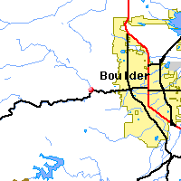
Monitoring site information: |
|

|
- Location: Boulder Creek at Orodell
- Name: BC-ORO
- Type: Composite
- Frequency: Monthly
- Longitude: 105 ° W 19'
- Latitude: 40 ° N 85'
- Elevation: 5825 feet asl
- Site photo
|
|
| Downstream Site: Boulder Creek at Eben G. Fine Park |
| Upstream Site: North Boulder Creek at Boulder Falls |
|
| Plot Label |
Date |
DO%
- |
| 01 |
January, 2000 |
No Data |
| 02 |
February, 2000 |
No Data |
| 03 |
March, 2000 |
No Data |
| 04 |
April, 2000 |
No Data |
| 05 |
May, 2000 |
No Data |
| 06 |
June, 2000 |
No Data |
| 07 |
July, 2000 |
No Data |
| 08 |
August, 2000 |
No Data |
| 09 |
September, 2000 |
No Data |
| 10 |
October, 2000 |
No Data |
| 11 |
November, 2000 |
No Data |
| 12 |
December, 2000 |
No Data |
| *value below detection limit: |
|---|
| Detection Limit (if available) |
|
|---|
|
Preliminary Data - subject to revision
|
|
Select on the parameter name to view all DO Percent of Saturation time series plots on the basin map.
Select on the table date to view stream DO Percent of Saturation profiles observed on that date.
Select here to view all parameters at this site.
|
Thank You!
BASIN was a community project which benefitted from over 1000 hours of
public volunteer time. BASIN was highlighted by the US EPA
in a national case study in its 2001 handbook Delivering Timely Environmental Information to Your Community.
Thank you to all volunteers, and especially to the late Jim Waterman, BASIN Project Coordinator!
|
|
Home
| Site Map
| Glossary
| Bibliography
| Contributors
About BASIN
| Attribution
| Feedback
| Search
|
