Tier I: General Public Access
next page previous
page
To understand the access opportunities available to the general public,
start with the official Open Space map which was just updated last year.
According to the map (which is reprinted below) the general public has
five options for accessing Open Space trails in this area:
-
The "Mesa" trailhead
-
The "South Boulder Creek West" trailhead
-
The Shanahan Ridge / Hardscrabble Drive trailhead
-
The Wildwood/Public Service trailhead
-
NCAR
These options are discussed below.

The " Mesa" Trailhead
At Mesa/Dowdy Draw trailhead the amount of available parking has been sharply
reduced in recent years by converting some of the parking lot into a picnic
area and prohibiting roadside parking. The result is that large numbers
of people are routinely being turned away on busy weekend days. This
represents the first time that Open Space has, in effect, undertaken an
access rationing system. One indicator of the extent of the unmet
demand for trail access is the large number of illegally parked and ticketed
cars. People really don't do this unless they feel that they have
no alternative.
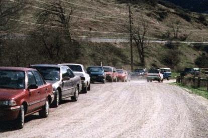
All of the safely, but illegally, parked cars in this picture have
tickets.
The "South Boulder Creek West" Trailhead
Additional (but increasingly crowded) parking is available from the South
Foothills highway at the South Boulder Creek West trailhead. This inferior
access point requires a lengthy and boring approach march before visitors
can get to the scenic mesas and cliffs that they really want to visit.
This is a good example of the kind of inferior "Tier I" access which is
available to the general public.
The Shanahan Ridge / Hardscrabble Drive Trailhead
At the Shannahan Ridge Trailhead at the end of Hardscrabble Drive visitors
are greeted with a sign informing them that
all available
parking is reserved for homeowners association members and guests. Nothing
directs visitors to alternative parking or access points.
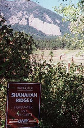
The Hardscrabble Drive trailhead.
The Wildwood/Public Service Trailhead

Visitors seeking the-hard-to-find Wildwood trail head will discover
only an access road to the Public Service substation. While there are plenty
of regulatory signs, there is nothing indicating that this is the
official beginning of the truly spectacular Bear Creek trail.
NCAR Trailhead
The Open Space Department argues that the official trailhead for this area
is located at NCAR. While NCAR does provide access to the Mesa Trail
and points west, I doubt that anyone would use it to access the lower Bear
Creek or Shanahan Ridge trails. To reach these trailheads one would
have to either bushwack off the side of the NCAR mesa or walk roads and
city streets for a couple of miles to get to the trailhead.
The Bottom Line
The bottom line is that general public access to the Mesa Trail area is
increasingly limited. And, access in the Shanahan Ridge/Bear Creek
area is even worse. To compare this with access enjoyed by neighbors
click
here.