|
|

|
City of Boulder Drinking Water Quality Program |
|
Boulder Creek Watershed
Water Quality Data Time Series for 1999
Dry Creek |
Preliminary Data - subject to revision
|
|
|
|
|
|
|
|
|
|
|
|
|
|
|
|
|
|
|
|
 Indicates no data available Indicates no data available |  Indicates data exceeds plot scale. Indicates data exceeds plot scale. |
|
|
|
|
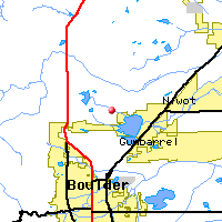
Monitoring site information: |
|
- Location: Dry Creek
- Name: DC
- Type: Composite
- Frequency: Monthly
- Longitude: 105 ° W 14'
- Latitude: 40 ° N 52'
- Elevation: feet asl
- Site photo
|
|
|
| Plot Label |
Date |
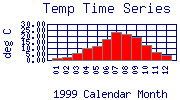
Temp
° C |
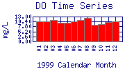
DO
mg/L |
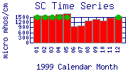
SC
µ mhos/cm |
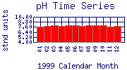
pH
stnd units |
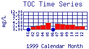
TOC
mg/L |
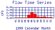
Flow
cfs |
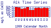
Alk
mg/L as CaCO3 |
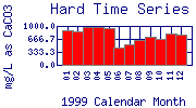
Hard
mg/L as CaCO3 |
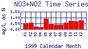
NO3+NO2
mg/L as N |
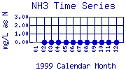
NH3
mg/L as N |
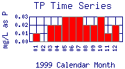
TP
mg/L as P |
OP_Dis
mg/L as P |
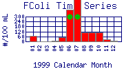
FColi
#/100 mL |
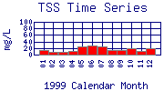
TSS
mg/L |
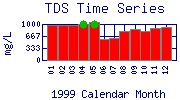
TDS
mg/L |
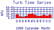
Turb
NTU |
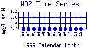
NO2
mg/L as N |
| 01 |
January, 1999 |
1.98 |
10.61 |
1594 |
7.71 |
No Data |
0.23 |
314.0 |
896.0 |
0.56 |
0.00* |
0.01 |
0.00* |
68 |
14 |
972 |
19.70 |
No Data |
| 02 |
February, 1999 |
2.72 |
10.49 |
1598 |
7.83 |
2.14 |
0.23 |
305.0 |
865.0 |
0.60 |
No Data |
0.00* |
0.00* |
2 |
9 |
975 |
8.88 |
No Data |
| 03 |
March, 1999 |
5.51 |
11.29 |
1597 |
7.93 |
2.73 |
0.19 |
259.4 |
964.0 |
0.24 |
No Data |
0.02 |
0.00* |
0* |
8 |
974 |
6.32 |
No Data |
| 04 |
April, 1999 |
10.20 |
9.69 |
1650 |
7.76 |
3.12 |
0.26 |
272.0 |
959.0 |
0.19 |
No Data |
0.02 |
0.00* |
12 |
10 |
1006 |
10.30 |
No Data |
| 05 |
May, 1999 |
11.77 |
9.88 |
1713 |
7.99 |
4.83 |
1.24 |
312.0 |
939.0 |
0.92 |
No Data |
0.03 |
0.00* |
52 |
26 |
1045 |
22.80 |
No Data |
| 06 |
June, 1999 |
17.15 |
10.45 |
939 |
7.96 |
No Data |
2.24 |
223.0 |
450.0 |
0.48 |
No Data |
0.03 |
0.00* |
380 |
29 |
573 |
24.50 |
No Data |
| 07 |
July, 1999 |
23.23 |
11.30 |
989 |
7.87 |
4.00 |
1.57 |
220.0 |
516.0 |
0.40 |
No Data |
0.03 |
0.00* |
590 |
24 |
603 |
18.80 |
No Data |
| 08 |
August, 1999 |
21.56 |
12.22 |
1304 |
7.97 |
3.61 |
0.61 |
280.4 |
649.2 |
0.42 |
No Data |
0.02 |
0.00* |
110 |
15 |
795 |
9.30 |
No Data |
| 09 |
September, 1999 |
18.97 |
8.82 |
1395 |
7.92 |
3.17 |
0.47 |
292.0 |
728.0 |
0.60 |
No Data |
0.02 |
0.00* |
110 |
15 |
851 |
12.50 |
No Data |
| 10 |
October, 1999 |
12.88 |
9.09 |
1312 |
7.92 |
3.43 |
0.51 |
278.0 |
668.0 |
0.76 |
No Data |
0.03 |
0.00* |
110 |
19 |
800 |
18.40 |
No Data |
| 11 |
November, 1999 |
6.83 |
9.94 |
1473 |
7.63 |
2.26 |
0.38 |
289.0 |
798.0 |
0.72 |
No Data |
0.01 |
0.00* |
26 |
12 |
899 |
13.40 |
No Data |
| 12 |
December, 1999 |
3.87 |
10.60 |
1524 |
7.84 |
2.47 |
0.34 |
287.1 |
784.0 |
0.80 |
No Data |
0.02 |
0.00* |
6 |
19 |
930 |
18.40 |
No Data |
| * indicates measured value below analysis detection limit listed below: |
|---|
| Lower Detection Limit |
0.0 | | 1.0 | NA | | | 1.0 | 0.1 | 0.01 | 0.01 | 0.0002 | 0.03 | 1.0 | 1 | 1 | 0.01 | 0.001 |
|---|
|
Preliminary Data - subject to revision
|
|
Select on the parameter name to view more detailed information on that parameter at this station.
Select on the table date to view stream data profiles observed on that date.
|
INVITATION:
BASIN is a community project actively seeking public participation. We
appreciate all feedback and welcome comments, suggestions and contributions.
To find out more about how you can be involved,
click here.
|
|
Home
| Site Map
| Glossary
| Bibliography
| Contributors
About BASIN
| Attribution
| Feedback
| Search
|