City of Longmont Water Quality Monitoring
Saint Vrain Watershed
Saint Vrain River
Longitudinal Total Phosphate Profiles for May, 2000

Preliminary Data - subject to revision


Marker Indicates no data available
Marker Indicates data exceeds plot scale.

Information on Total Phosphate:

Phosphorus is generally found as phosphate (PO4-3). The primary sources of phosphates to surface water are detergents, fertilizers, and natural mineral deposits.

More general information about Total Phosphate
Measurement of Total Phosphate
Factors affecting Total Phosphate
Standards regarding Total Phosphate
Interpretation of Saint Vrain Total Phosphate data
Data Source: City of Longmont Water Quality Monitoring
Point of Contact: Sheila Murphy
Collection and Analysis notes
Analysis method: SM 4500-P B.5

Indicated monitoring site:

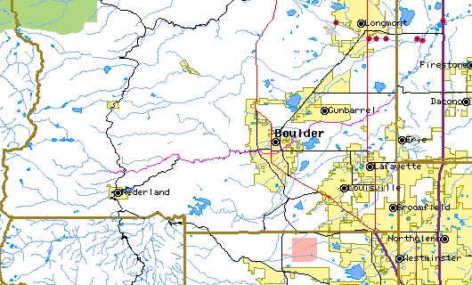
The above map indicates water quality monitoring sites. To view data at a specific site select it from the map with the mouse.


Plot Label SiteName TP
mg/L as P
SVAIR St. Vrain River at Airport Road No Data
SVaWWTP St. Vrain River above WWTP Effluent 0.07
SVaCL St. Vrain River at County Line Road 1.21
SVaBC St. Vrain River at Boulder Creek No Data
*value below detection limit:
Detection Limit (if available) 0.025

Preliminary Data - subject to revision

Select on the parameter name to view more detailed information for that parameter in this month. Select on the site name to view data time series observed at that station. For monitoring site locations see site location map.

Return to the BASIN water quality catalog

Return to the BASIN environmental data catalog


INVITATION: BASIN is a community project actively seeking public participation. We appreciate all feedback and welcome comments, suggestions and contributions. To find out more about how you can be involved, click here.

Home | Site Map | Glossary | Bibliography | Contributors
About BASIN | Attribution | Feedback | Search
Last Page Update - Wednesday December 28, 2005
IMS support provided by Enfo.com