
|
|
|
|
1894,
May 31 - June 2 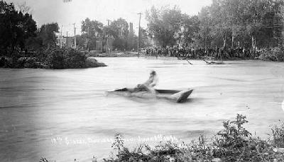
Boating on Boulder Creek at 12th Street, now Broadway on June 1, 1894. Photo copyright by the Denver Public Library. Visit the BASIN Gallery for more historic flood images. "May 29 - June 2. Heavy rains fell over the mountains extending from the Colorado-Wyoming border southward into the Republican and Arkansas river basins. Rainfall over the Boulder and South Boulder Creek basins was particularly heavy. Rainfall records for a 96 hour period ending at 3 AM on June 1894 show that the mountain drainage area received from 4.5 to 6 inches of precipitation. Rainfall amounts over the high plains gradually decreased from west to east varying from 5 inches at Boulder to approximately 2.5 inches at the mouth of Boulder Creek. The mountain rainfall, combined with the snowmelt runoff to produce the greatest flood known at Boulder, which came roaring down the valley during the night of 30 May 1894. Buildings, bridges, and even long sections of roads and railroads were washed away. Although damages were extensive, a dollar amount was not estimated at that time." From US Army Corps of Engineers, August 1969 Floodplain Mapping of Boulder Creek. Information compiled by Elizabeth Black. |