|
|
|
|
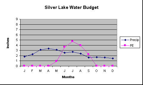
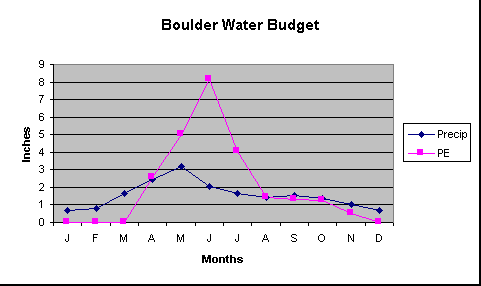
What is a water budget? A water budget reflects the relationship between input and output of water through a region. The water balance graph shows precipitation and potential evapotranspiration both as line graphs. Thus we have a direct comparison of supply of water and the natural demand for water. It is possible to identify the periods when there is plenty of precipitation and when there is not enough. The following terms will be used in the questions that follow:
Following is a data table of with monthly and total compares of Precipitation and Potential Evapotranspiration for Silver Lake, west and north of Nederland, and Boulder. The data is a composite of measurements.
Questions: 1. During what months does Boulder have a water surplus? A water deficit? During what months does Silver Lake have a water surplus? A water deficit? 2. Which place has an overall deficit for the year? Which place has an overall surplus for the year? Can you explain why? 3. During what month is Boulder's water deficit the smallest? During what month is Boulder's water deficit the largest? During what month is Boulder's water surplus the smallest? During what month is Boulder's water surplus the largest? During what month does Boulder's water deficit peak? Give two reasons why the rise is so dramatic 4. When does Silver Lake not have any PE? Explain why. 5. List the three places that Boulder gets its water from. 6. Boulder is downstream from Silver Lake. What would you expect to happen if the Silver Lake area had a very large surplus? When would you experience the most problems connected with the surplus and why? What could planners do to minimize these problems. Additional activities: Chart a water balance chart showing potential evaptranspiration (PE) and precipitation for (P) . You can use data from the Western Regional Climate Center which has a summary of Climate Data in Colorado and numerous other resources on precipitation and climate. Here are the addresses for several stations in the Boulder area: Allenspark Also check out the National Weather Service's summary of hydrology in the Denver area which includes information from the Urban Drainage and Flood Control District (UDFCD) monitoring network. Part of the UDFCD's flood warning system includes the Alert system, with real time data from their network of stations. They have excellent rainfall maps that you can create on demand of the region including some of the Boulder area. To find out more about the complexities of evapo-transpiration, visit the Colorado ET Network . |