BASIN Home
BASIN Text Image
Current Theme: Watershed
Hydrograph

HYDROGRAPH HISTORY

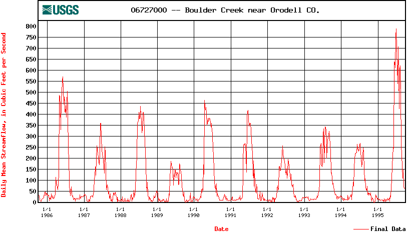
A hydrograph provides a way of seeing seasonal and yearly changes in the flow or discharge of a waterway. (See an example for Boulder Creek between 1986 and 1996 below. Note the higher than normal volume of water for 1996.) With winter flows below 50 cfs and peak runoff in the late spring and early summer in the hundreds of cfs, this seasonal flux has major implications in terms of water storage and flood preparation.

You can plot your own charts for up to ten year intervals using data collected by the USGS stream gauge stations in the Boulder Creek Watershed. The numbers on the left as the official station numbers.

06725500 -- Middle Boulder Creek at Nederland CO.
06726000 -- North Boulder Creek at Silver Lake CO.
06726500 -- North Boulder Creek near Nederland CO.
06726900 -- Bummers Gulch near El Vado
06727000 -- Boulder Creek near Orodell
06727500 -- Four Mile Creek at Orodell
06730200 -- Boulder Creek at 75th Street
06730500 -- Boulder Creek at Mouth
06729000 -- South Boulder Creek near Rollinsville CO.
06729300 -- South Boulder Creek at Pinecliffe CO.
06729500 -- South Boulder Creek near Eldorado Springs CO.
06730300 -- Coal Creek near Plainview
06730400 -- Coal Creek near Louisville

Return to Watershed Address
Return to Natural System


INVITATION BASIN is a community project actively seeking public participation. We appreciate all feedback and welcome comments, suggestions and contributions. To find out more about how you can be involved, click here. Help BASIN serve your needs, take our "10 questions in 10 seconds" survey.

BASIN is supported by the US EPA, the City of Boulder, the Keep it Clean Partnership, BCWI and BCN

Home | Site Map | Glossary | Bibliography | Contributors
About BASIN | Attribution | Feedback | Search
Last Page Update - Tuesday December 27, 2005