|
|
|
The Boulder Creek Hydroelectric Flood Wave
by John Moody, Hydrologist, US Geological Survey
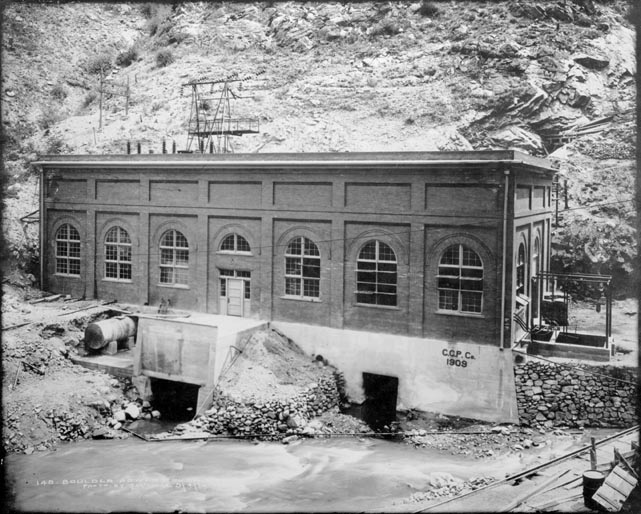
As daylight gets shorter and darkness gets longer in the fall, the Public Service Company of Colorado starts producing extra electricity at the Orodell power station in Boulder Canyon to meet the extra power demands of winter. The power plant is operated for peak power needs from about November through the following March and can produce a maximum of 18 Megawatts of electrical power. The generators are put on line at about 5 p.m. each day, operated for about 2.5 hours, and discharge water at a rate of about 4.2 m3/s (148 ft3/s) into Boulder Creek. This creates a water wave traveling on a baseflow in Boulder Creek of about 0.5 m3/s (17.6 ft3/s, average of December, 1994, January 1996, and February 1996; U. S. Geological Survey--Colorado, 1994). The amount and timing of the release is quite regular so that the amplitude and speed of this flood wave could be studied using one instrument on different days at different sites downstream rather than having a large number of instruments deployed simultaneously at different sites. Boulder Creek Channel The flood wave was studied during the winter of 1995-96
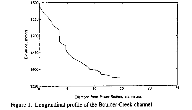
from where it originates in the mountains in Boulder Canyon to where it
flows under the 109th Street bridge out onto the plains. The channel drops
131 m from the power plant (elevation 1789 m) to the mouth of Boulder
Canyon (1658 m) with an average channel slope of 0.028 or nearly 3%. Over
the next 10 km through the city of Boulder, the channel slope is about
0.008 and decreases to 0.004 beyond 95th Street on the plains. In the
canyon the width of the creek has probably been narrowed in most places
by the construction of Highway 119. At the Orodell gage the channel width
is 10 m, through the City of Boulder it varies from 6-10 m wide, and is
around 15 m wide out on the plains. In the canyon, the bed roughness is
dominated by large rocks and boulders often protruding through the water;
in the city, artificial pools and diversion structures disrupt the flow
but the bed is sand, gravel, and cobbles; and on the plains the bed is
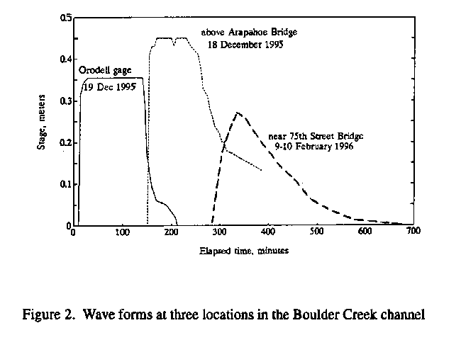
mostly sand. Hydrograph The hydrograph of the flood wave approximates a square
wave near the power plant in the canyon and is transformed into a triangular
wave farther downstream near 75th Street on the plains. At the Orodell
gage located 0.48 km downstream from the power plant the amplitude of
the wave is 0.35 m and it arrives at the gage in about 10 minutes. After
the wave leaves the canyon (4.8 km downstream from the power plant), the
amplitude seems to remains at about 0.45 m as it passes through Boulder.
Between 63rd Street and the 95th Street bridge (9.5 km), the amplitude
decreases from 0.37 m to 0.17 m as the wave passes through a less engineered
reach and has metamorphosed to a nearly triangular wave.
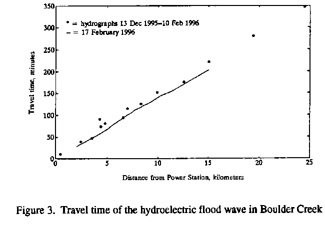
Speed of the flood wave The speed of the flood wave was measured by determining the travel distance along the channel from maps and by recording the arrival time of the wave at specific sites using two different methods. The first method was to install a continuous water-level recorder at a fixed site and record the water level as the flood wave passed during one night and then move the recorder to a new site and record a different flood wave on another night. The second method was to follow the same wave during the evening and record the arrival time of the flood wave at specific sites. The phase speed or speed of the wave form is the slope
of a graph showing travel distance as a function of travel time. Phase
speed of the wave is faster than the speed of the water. The phase speed
ranged from 0.8 to 1.8 m/s with an average of 1.2 ± 0.2 m/s. Estimates
of the cross-sectionally averaged water speed (assuming discharge of 4.2
m3/s) at 11 cross sections across both pools and riffles between
Broadway and the 55th Street bridge was 1.0 ± 0.2 m/s. The ratio of phase
speed to water speed is therefore 1.2, slightly less than the theoretical
value of 1.5 if the channel is rectangular and the frictional resistance
is constant (Henderson, 1966).
A hydroelectric flood waves travels down Boulder Creek during the fall and winter. It is released from the Orodell Power Plant in Boulder Canyon between 4:30 and 5:30 p.m. and passes under the Broadway bridge about 2 hours later. The wave form travels at about 1.2 m/s down Boulder Canyon and through the City of Boulder and the water discharge as the wave passes a fixed point is about 4 m3/s with water speeds of about 1 m/s. The amplitude of the original square wave in Boulder Canyon is about 0.4 m and this changes to a triangular form with a peak amplitude of about 0.2 m near the 95th Street bridge on the plains. ReferencesHenderson, F. M., 1966, Open Channel Flow, Chapter 9, Macmillian Company, New York, 521 p. U. S. Geological Survey--Colorado, 1994, Water Resources Data for Colorado Water Year 1994, U. S. Geological Survey Water-Data Report CO-94-1. AcknowledgmentJeff Navarre and other people at the Public Service Company of Colorado were very helpful in providing information and at one time almost daily telephone calls to find out when the generators were started. Boulder County Land Use Department provided me with various scale maps for determining channel distance; Deborah Martin helped me make discharge measurements in freezing cold water; Dr. Alfred Redfield provided money to build the tide gage which was used as a water level recorder and Larry Barber spurred me to write this short memo and Deborah Martin, Steve Wiele, and Jim Bennett who made improvements to the memo. |