Flood History in the Boulder Area
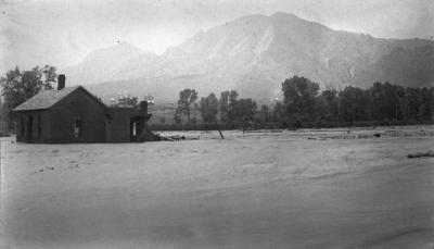
Water Street, now Canyon Blvd., on June
1, 1894.
Photo copyright by the Denver Public Library.
Visit the BASIN Gallery for more historic
flood images.
Due to its location near the mouth of numerous canyons, the Boulder
area is a major flash flood risk. Following are descriptions compiled
by Elizabeth Black of some of the flash floods that have occurred in
the region beginning with the flood of 1894. Such floods-- and many
larger-- have happened before the area was developed.... and will sooner
or later happen again.
- 1894 (100 Year Flood-- over 10,000 cubic
feet per second on Boulder Creek)
- 1896 (Damage around the city of Boulder)]
- 1896 (Storm and damage around Marshall
and Coal Creek drainage)
- 1906 (Flood down Sunshine Canyon)
- 1909 (Two Die in Two Mile Creek)
- 1916 (Four Mile Canyon Creek flooding)
- 1921 (Coal Creek)
- 1929 (Cloudburst causes flooding)
- 1938 (Eldorado Springs and South Boulder
Creek flooding)
- 1941 (Two Mile Creek)
- 1950 (Four Mile Canyon Creek)
- 1951 (Four Mile Canyon Creek)
- 1955 (Two Mile Creek and Four Mile Canyon
Creek)
- 1969 (Two Mile Creek and Bear Creek flooding)
For additional flash flood information, visit
BASIN Watershed's Flash
Flood in the Boulder Area , Flood
History and Find Your Watershed
Address.
|
