|
|
|
The
Boulder Creek Millennium Baseline Study (BCMB) is gathering data on field
parameters and major element, nutrient, metal, pesticide and pharmaceutical
concentrations in Boulder Creek during high flows in June 2000 and low flows
in October, 2000. This data will be analyzed over the next several months and
the results will be released in phases on the BASIN website.
The BCMB high flow water quality data is now available along with an initial analysis provided in this document.
The
first phase of results from the BCMB study are now available. This first phase
contains data for water temperature, pH, dissolved oxygen, specific
conductance, total organic carbon, flow rate, alkalinity, hardness,
nitrate+nitrite, nitrite, ammonia, phosphate, fecal coliform, total suspended
solids, total dissolved solids, and turbidity. This data monthly data gathered
by the City of Boulder. Water quality is excellent in
samples from North and Middle Boulder Creeks near the headwaters. There is some
degradation as the creek moves down Boulder Canyon, further degradation through
the City of Boulder, and significant degradation east of the City of Boulder.
The parameters of most concern to the health of Boulder Creek are ammonia,
nitrate, and phosphorus. Some samples from Boulder Creek also indicated
elevated levels of fecal coliform. To see the data,
select here
.
The
major factors affecting water quality in Boulder Creek are:
Geology
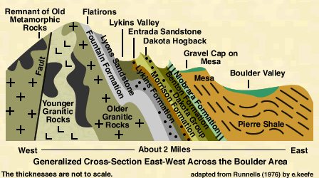
Geology
and topography are significant factors in changing water quality in the creek as
it moves from mountains to plains. As Boulder Creek drops in elevation, water
temperature warms up, along with air temperature. In the mountains, Boulder
Creek passes over granitic and metamorphic rocks that aren’t very reactive;
when it moves into the plains, the geology is dominated by sedimentary rocks,
including sandstones and shales. Increases in pH, specific conductivity,
alkalinity, and TDS reflect the more easily weathered, calcite-bearing
sedimentary rocks. For more information on geology in the Boulder area, visit
the BASIN geology page
Urban Runoff

Human activity, such as urban and highway runoff, affects water quality in the creek as it passes through Boulder Canyon and the City of Boulder. Fecal coliform concentrations were higher in Boulder Creek at 30th Street (BC-30) and 61st Street (BC-61) in Boulder than at any other site. Many factors could contribute to these elevated concentrations, including faulty sewer systems and animal waste left in or near the stream. Fecal coliform concentrations were 170 colonies/100 ml at these sites; the primary recreation standard (swimming, kayaking, etc.) is 200 colonies/100 ml (for more on standards, see the BASIN Water Quality Standards discussion.
Wastewater Effluent
Effluent from the Wastewater Treatment Plant (WWTP),
located just upstream of 75th Street, also affects water quality.
The WWTP removes a tremendous amount of the waste from our houses and
businesses, and discharges the treated water to Boulder Creek (for more
information on the WWTP, see the
City of Boulder's Public Works webpage (
at
http://www.ci.boulder.co.us/publicworks/depts/utilities/water_treatment/plants/wasteplant.htm).
 The WWTP meets all state requirements for discharging to the creek. However,
the plant cannot remove everything we contribute to the sanitary sewer. The
June water quality data showed increases in specific conductivity, total
dissolved solids (TDS), alkalinity, hardness, ammonia, phosphorus, nitrate, and
nitrite at the 75th Street sampling site (BC-75). Dissolved oxygen
at BC-75 dropped, because the WWTP effluent contributes organic waste and
nutrients, which encourage the growth of bacteria. These bacteria consume the
waste and remove oxygen from the water.
The WWTP meets all state requirements for discharging to the creek. However,
the plant cannot remove everything we contribute to the sanitary sewer. The
June water quality data showed increases in specific conductivity, total
dissolved solids (TDS), alkalinity, hardness, ammonia, phosphorus, nitrate, and
nitrite at the 75th Street sampling site (BC-75). Dissolved oxygen
at BC-75 dropped, because the WWTP effluent contributes organic waste and
nutrients, which encourage the growth of bacteria. These bacteria consume the
waste and remove oxygen from the water.
Algal Growth
Downstream of the WWTP and the City of Boulder, the environment of Boulder Creek changes in several ways. There are fewer trees to shade the creek and prevent bank erosion, and the flow rate is lower, due to the many diversion from the Creek. These factors cause the creek water temperature to warm up. The nutrients (nitrate and phosphate) from the WWTP and from fertilizer runoff, along with higher temperatures and direct sunlight, cause significant plant growth to occur. The rapid photosynthesis that occurs during the day causes pH and dissolved oxygen levels to increase significantly. At night, when plants, bacteria, and animals are undergoing respiration, pH and dissolved oxygen levels drop. The high pH and temperature affect the toxicity of ammonia in the creek. At high temperatures and pH (e.g., above 9), ammonia begins to convert to unionized ammonia, which is much more toxic to aquatic organisms than the ammonium ion.
Diversions

The degree to which water quality in the creek is affected is largely related to the flow rate. Downstream of the WWTP, this is particularly significant, because it affects the proportion of wastewater effluent to total flow in the creek. During times of high flow in the creek (e.g., from April to September, when flow in Boulder Creek is higher due to snowmelt runoff and thunderstorms) the greater amount of water dilutes chemical concentrations in the creek. During low-flow, wastewater effluent can comprise over half of the total flow, and chemical concentrations are often higher. The flow rate in Boulder Creek is also largely affected by the many diversions that take water from it and return to the creek. The flow at BC-ORO (in Boulder Canyon at the USGS gauging station) has the highest flow (97 cfs) of those measured; at this point, North and Middle Boulder Creek have joined forces. By the time the stream reaches 30th Street in Boulder, a significant amount of flow has been diverted by several ditches. By the time Boulder Creek reaches the Saint Vrain River, the flow in the creek was at its lowest (16 cfs).
INVITATION BASIN is a community project actively seeking public participation. We appreciate all feedback and welcome comments, suggestions and contributions. To find out more about how you can be involved, click here. | |||||
|
About BASIN | Attribution | Feedback | Search | |||||