|
|
|
City of Boulder Drinking Water Quality Program |
|
Boulder Creek Watershed
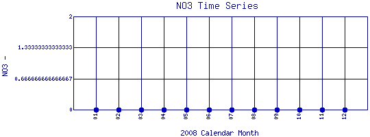
Water Quality Time Series for 2008
Boulder Feeder Canal at Boulder Reservoir |
Preliminary Data - subject to revision
|
|
|
 |
 Indicates no data available Indicates no data available |
 Indicates data exceeds plot scale. Indicates data exceeds plot scale. |
|
|
Information on :
|
|
More general information about
|
|
|
Interpretation of Boulder Creek data
|
|
|
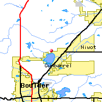
Monitoring site information: |
|

|
- Location: Boulder Feeder Canal at Boulder Reservoir
- Name: BFCaBR
- Type: Composite
- Frequency: Monthly
- Longitude: 105 ° W 13'
- Latitude: 40 ° N 53'
- Elevation: feet asl
- Site photo
|
|
|
| Plot Label |
Date |
NO3
|
| 01 |
January, 2008 |
No Data |
| 02 |
February, 2008 |
No Data |
| 03 |
March, 2008 |
No Data |
| 04 |
April, 2008 |
No Data |
| 05 |
May, 2008 |
No Data |
| 06 |
June, 2008 |
No Data |
| 07 |
July, 2008 |
No Data |
| 08 |
August, 2008 |
No Data |
| 09 |
September, 2008 |
No Data |
| 10 |
October, 2008 |
No Data |
| 11 |
November, 2008 |
No Data |
| 12 |
December, 2008 |
No Data |
| *value below detection limit: |
|---|
| Detection Limit (if available) |
|
|---|
|
Preliminary Data - subject to revision
|
|
Select on the parameter name to view more detailed information on that parameter at this station.
Select on the table date to view stream data profiles observed on that date.
|
INVITATION:
BASIN is a community project actively seeking public participation. We
appreciate all feedback and welcome comments, suggestions and contributions.
To find out more about how you can be involved,
click here.
|
|
Home
| Site Map
| Glossary
| Bibliography
| Contributors
About BASIN
| Attribution
| Feedback
| Search
|
