| |||||||||||||||||||||||||||||||||||||||||||||
 | |||||||||||||||||||||||||||||||||||||||||||||
 Indicates no data available Indicates no data available | |||||||||||||||||||||||||||||||||||||||||||||
 Indicates data exceeds plot scale. Indicates data exceeds plot scale. | |||||||||||||||||||||||||||||||||||||||||||||
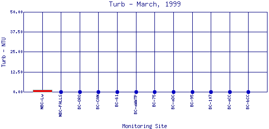
Turbidity
is a measure of the cloudiness of the water. Cloudiness is caused by suspended solids or organic matter including silt, microorganisms, plant fibers, sawdust chemicals and coal dust. High levels of turbidity can block light from reaching submerged aquatic vegetation and can raise surface water temperatures because the suspended particles absorb heat from sunlight. The most frequent causes of turbidity are from logging, road and building construction, and mining activity. Turbidity affects fish by decreasing light penetration thus reducing the amount of photosynthesis taking place in the water. This reduces the amount of oxygen available to fish. Large amounts of suspended solids can also clog fish gills, and it affects their ability to see and catch foo | |||||||||||||||||||||||||||||||||||||||||||||
| |||||||||||||||||||||||||||||||||||||||||||||
|
| |||||||||||||||||||||||||||||||||||||||||||||
| |||||||||||||||||||||||||||||||||||||||||||||
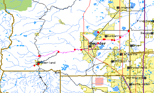
The above map indicates water quality monitoring sites. To view data at a specific site select it from the map with the mouse. | |||||||||||||||||||||||||||||||||||||||||||||
| |||||||||||||||||||||||||||||||||||||||||||||
Preliminary Data - subject to revision | |||||||||||||||||||||||||||||||||||||||||||||
Return to the BASIN water quality catalogReturn to the BASIN environmental data catalog | |||||||||||||||||||||||||||||||||||||||||||||
|
| |||||||||||||||||||||||||||||||||||||||||||||
|
About BASIN | Attribution | Feedback | Search | |||||||||||||||||||||||||||||||||||||||||||||