|
|

|
City of Boulder Storm Water Quality Program |
|
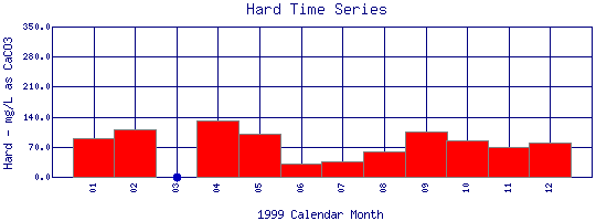
Boulder Creek Watershed
Total Hardness Time Series for 1999
Boulder Creek at 61st St. |
Preliminary Data - subject to revision
|
|
|
 |
 Indicates no data available Indicates no data available |
 Indicates data exceeds plot scale. Indicates data exceeds plot scale. |
|
|
Information on Total Hardness:
Hardness
generally refers to the amount of calcium and magnesium in water. In household use, these cations (ions with a charge greater than +1) can prevent soap from sudsing and leave behind a white scum in bathtubs. In the aquatic environment, calcium and magnesium help keep fish from absorbing metals, such as lead, arsenic, and cadmium, into their bloodstream through their gills. Therefore, the harder the water, the less easy it is for toxic metals to absorb onto gills. Water in the Boulder Creek watershed is generally soft because the water comes mainly from melting snow which is low in minerals and metals. |
|
More general information about Total Hardness
|
|
|
Interpretation of Boulder Creek Total Hardness data
|
|
|
|
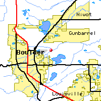
Monitoring site information: |
|

|
- Location: Boulder Creek at 61st St.
- Name: BC-61
- Type: Composite
- Frequency: Monthly
- Longitude: 105 ° W 12'
- Latitude: 40 ° N 22'
- Elevation: 5160 feet asl
- Site photo
|
|
| Downstream Site: Boulder Creek above WW Plant |
| Upstream Site: Boulder Creek at Eben G. Fine Park |
|
| Plot Label |
Date |
Hard
mg/L as CaCO3 |
| 01 |
January, 1999 |
90.0 |
| 02 |
February, 1999 |
110.0 |
| 03 |
March, 1999 |
No Data |
| 04 |
April, 1999 |
130.0 |
| 05 |
May, 1999 |
100.0 |
| 06 |
June, 1999 |
30.0 |
| 07 |
July, 1999 |
35.0 |
| 08 |
August, 1999 |
60.0 |
| 09 |
September, 1999 |
105.0 |
| 10 |
October, 1999 |
85.0 |
| 11 |
November, 1999 |
70.0 |
| 12 |
December, 1999 |
80.0 |
| *value below detection limit: |
|---|
| Detection Limit (if available) |
0.1 |
|---|
|
Preliminary Data - subject to revision
|
|
Select on the parameter name to view all Total Hardness time series plots on the basin map.
Select on the table date to view stream Total Hardness profiles observed on that date.
Select here to view all parameters at this site.
|
INVITATION:
BASIN is a community project actively seeking public participation. We
appreciate all feedback and welcome comments, suggestions and contributions.
To find out more about how you can be involved,
click here.
|
|
Home
| Site Map
| Glossary
| Bibliography
| Contributors
About BASIN
| Attribution
| Feedback
| Search
|
