|
|

|
City of Boulder Storm Water Quality Program |
|
Boulder Creek Watershed
Water Quality Data Time Series for 2001
Coal Creek Above Boulder Creek Confluence |
Preliminary Data - subject to revision
|
|
|
|
|
|
|
|
|
|
|
|
|
|
|
|
|
|
|
|
|
 Indicates no data available Indicates no data available |  Indicates data exceeds plot scale. Indicates data exceeds plot scale. |
|
|
|
|
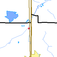
Monitoring site information: |
|

|
- Location: Coal Creek Above Boulder Creek Confluence
- Name: CC-confl
- Type: Composite
- Frequency: Monthly
- Longitude: 105 ° W 35'
- Latitude: 40 ° N 48'
- Elevation: 4955 feet asl
- Site photo
|
|
| Downstream Site: North Boulder Creek at Boulder Falls |
|
| Plot Label |
Date |
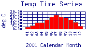
Temp
° C |
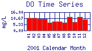
DO
mg/L |
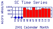
SC
µ mhos/cm |
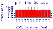
pH
stnd units |
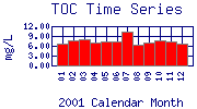
TOC
mg/L |
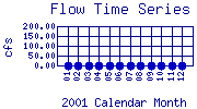
Flow
cfs |
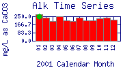
Alk
mg/L as CaCO3 |
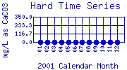
Hard
mg/L as CaCO3 |
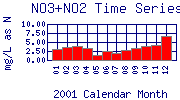
NO3+NO2
mg/L as N |
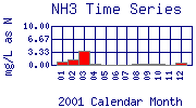
NH3
mg/L as N |
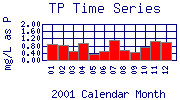
TP
mg/L as P |
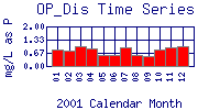
OP_Dis
mg/L as P |
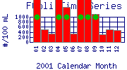
FColi
#/100 mL |
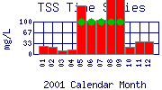
TSS
mg/L |
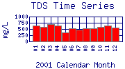
TDS
mg/L |
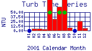
Turb
NTU |
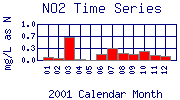
NO2
mg/L as N |
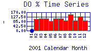
DO%
- |
| 01 |
January, 2001 |
3.70 |
10.92 |
No Data |
8.34 |
6.77 |
No Data |
269.0 |
No Data |
3.00 |
0.70 |
0.89 |
0.85 |
2400 |
24 |
630 |
No Data |
0.1 |
No Data |
| 02 |
February, 2001 |
5.60 |
11.23 |
No Data |
8.54 |
7.66 |
No Data |
236.0 |
No Data |
3.70 |
1.30 |
0.81 |
0.80 |
490 |
21 |
576 |
5.60 |
0.1 |
107.50 |
| 03 |
March, 2001 |
10.80 |
10.37 |
No Data |
8.56 |
7.85 |
No Data |
199.0 |
No Data |
4.00 |
3.60 |
0.49 |
1.01 |
330 |
10 |
682 |
5.61 |
0.7 |
111.60 |
| 04 |
April, 2001 |
10.80 |
10.35 |
956 |
8.53 |
6.98 |
No Data |
249.0 |
No Data |
3.30 |
0.30 |
0.95 |
0.87 |
9200 |
13 |
628 |
3.70 |
0.0* |
113.60 |
| 05 |
May, 2001 |
16.20 |
7.33 |
767 |
8.36 |
7.49 |
No Data |
207.0 |
No Data |
1.40 |
< 0.10* |
0.32 |
0.55 |
1400 |
150 |
352 |
98.30 |
0.0* |
88.70 |
| 06 |
June, 2001 |
20.70 |
8.09 |
722 |
8.54 |
7.29 |
No Data |
200.0 |
No Data |
2.60 |
< 0.10* |
0.48 |
0.57 |
330 |
102 |
516 |
32.00 |
0.2 |
112.50 |
| 07 |
July, 2001 |
24.30 |
8.07 |
981 |
8.41 |
10.30 |
No Data |
237.0 |
No Data |
1.90 |
< 0.10* |
1.12 |
0.94 |
1700 |
105 |
460 |
64.60 |
0.3 |
113.60 |
| 08 |
August, 2001 |
21.10 |
7.32 |
758 |
8.14 |
6.22 |
No Data |
208.0 |
No Data |
2.73 |
0.30 |
0.57 |
0.54 |
9200 |
172 |
526 |
97.70 |
0.2 |
95.20 |
| 09 |
September, 2001 |
18.90 |
12.13 |
787 |
8.11 |
7.04 |
No Data |
206.0 |
No Data |
3.30 |
0.40 |
0.45 |
0.48 |
1100 |
342 |
528 |
8.40 |
0.2 |
151.90 |
| 10 |
October, 2001 |
15.50 |
7.65 |
878 |
8.54 |
7.56 |
No Data |
232.0 |
No Data |
3.92 |
0.30 |
0.74 |
0.85 |
300 |
21 |
592 |
No Data |
0.2 |
94.90 |
| 11 |
November, 2001 |
11.50 |
12.08 |
874 |
8.30 |
7.30 |
No Data |
233.0 |
No Data |
4.30 |
0.10 |
1.07 |
0.94 |
490 |
38 |
638 |
26.30 |
0.1 |
132.80 |
| 12 |
December, 2001 |
5.40 |
9.61 |
869 |
8.26 |
6.52 |
No Data |
213.0 |
No Data |
6.70 |
0.60 |
1.02 |
1.01 |
460 |
40 |
568 |
6.97 |
0.1 |
92.20 |
| * indicates measured value below analysis detection limit listed below: |
|---|
| Lower Detection Limit |
0.0 | | 1.0 | NA | | | 1.0 | 0.1 | 0.1 | 0.1 | 0.03 | 0.03 | 20.0 | 1 | 1 | 0.01 | 0.001 | |
|---|
|
Preliminary Data - subject to revision
|
|
Select on the parameter name to view more detailed information on that parameter at this station.
Select on the table date to view stream data profiles observed on that date.
|
INVITATION:
BASIN is a community project actively seeking public participation. We
appreciate all feedback and welcome comments, suggestions and contributions.
To find out more about how you can be involved,
click here.
|
|
Home
| Site Map
| Glossary
| Bibliography
| Contributors
About BASIN
| Attribution
| Feedback
| Search
|
