|
|
|
City of Boulder Drinking Water Quality Program |
|
Boulder Creek Watershed
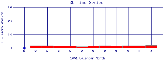
Specific Conductance Time Series for 2001
Como Creek where it enters Lakewood Res. |
Preliminary Data - subject to revision
|
|
|
 |
 Indicates no data available Indicates no data available |
 Indicates data exceeds plot scale. Indicates data exceeds plot scale. |
|
|
Information on Specific Conductance:
Specific Conductance
is a measure of how well water can pass an electrical current. It is an indirect measure of the presence of inorganic dissolved solids, such as chloride, nitrate, sulfate, phosphate, sodium, magnesium, calcium, and iron. These substances conduct electricity because they are negatively or positively charged when dissolved in water. The concentration of dissolved solids, or the conductivity, is affected by the bedrock and soil in the watershed. It is also affected by human influences. For example, agricultural runoff can raise conductivity because of the presence of phosphate and nitrate.
|
|
More general information about Specific Conductance
|
|
|
Interpretation of Boulder Creek Specific Conductance data
|
|
|
|
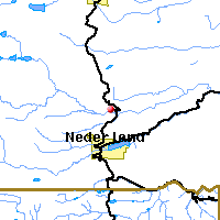
Monitoring site information: |
|

|
- Location: Como Creek where it enters Lakewood Res.
- Name: Como
- Type: Composite
- Frequency: Monthly
- Longitude: 105 ° W 30'
- Latitude: 39 ° N 59'
- Elevation: 8241 feet asl
- Site photo
|
|
| Downstream Site: North Boulder Creek at Boulder Falls |
|
| Plot Label |
Date |
SC
µ mhos/cm |
| 01 |
January, 2001 |
No Data |
| 02 |
February, 2001 |
62 |
| 03 |
March, 2001 |
59 |
| 04 |
April, 2001 |
51 |
| 05 |
May, 2001 |
55 |
| 06 |
June, 2001 |
35 |
| 07 |
July, 2001 |
50 |
| 08 |
August, 2001 |
56 |
| 09 |
September, 2001 |
54 |
| 10 |
October, 2001 |
58 |
| 11 |
November, 2001 |
62 |
| 12 |
December, 2001 |
66 |
| *value below detection limit: |
|---|
| Detection Limit (if available) |
1.0 |
|---|
|
Preliminary Data - subject to revision
|
|
Select on the parameter name to view all Specific Conductance time series plots on the basin map.
Select on the table date to view stream Specific Conductance profiles observed on that date.
Select here to view all parameters at this site.
|
INVITATION:
BASIN is a community project actively seeking public participation. We
appreciate all feedback and welcome comments, suggestions and contributions.
To find out more about how you can be involved,
click here.
|
|
Home
| Site Map
| Glossary
| Bibliography
| Contributors
About BASIN
| Attribution
| Feedback
| Search
|
