| |||||||||||||||||||||
 | |||||||||||||||||||||
 Indicates no data available Indicates no data available | |||||||||||||||||||||
 Indicates data exceeds plot scale. Indicates data exceeds plot scale. | |||||||||||||||||||||
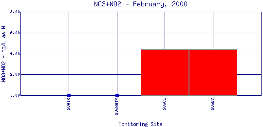
Nitrogen occurs in water in various forms, including nitrate (NO3), nitrite (NO2), and ammonia (NH3). Nitrate enters waterways from lawn fertilizer run-off, leaking septic tanks, animal wastes, industrial waste waters, sanitary landfills and discharges from car exhausts. The burning of fossil fuels releases NOX compounds into the air that fall as acid rain (HNO3). Nitrates in water can cause severe illness in infants and domestic animals. Ammonia is the decay product of animal proteins and is sometimes found in wastewater. Through the process of nitrification, ammonia in wastewater is oxidized to nitrite and then to nitrate by bacterial or chemical reactions. | |||||||||||||||||||||
| |||||||||||||||||||||
|
| |||||||||||||||||||||
| |||||||||||||||||||||
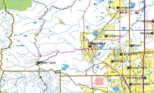
The above map indicates water quality monitoring sites. To view data at a specific site select it from the map with the mouse. | |||||||||||||||||||||
| |||||||||||||||||||||
Preliminary Data - subject to revision | |||||||||||||||||||||
Return to the BASIN water quality catalogReturn to the BASIN environmental data catalog | |||||||||||||||||||||
|
| |||||||||||||||||||||
|
About BASIN | Attribution | Feedback | Search | |||||||||||||||||||||