| |||||||||||||||||||||||||||||||||||||||||||||
 | |||||||||||||||||||||||||||||||||||||||||||||
 Indicates no data available Indicates no data available | |||||||||||||||||||||||||||||||||||||||||||||
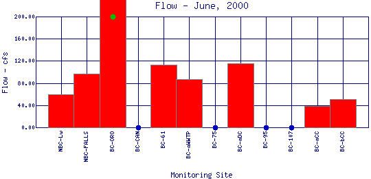
 Indicates data exceeds plot scale. Indicates data exceeds plot scale. | |||||||||||||||||||||||||||||||||||||||||||||
Flow is the volume of water moving past a point in a unit of time. Two things make up flow: the volume of water in the stream, and the velocity of the water moving past a given point. Flow affects the concentration of dissolved oxygen, natural substances, and pollutants in a water body. Flow is measured in units of cubic feet per second (cfs). Peak flows for Boulder Creek in the spring can reach as high as 300-800 cfs and as low as 10-50 cfs in the fall months. | |||||||||||||||||||||||||||||||||||||||||||||
| |||||||||||||||||||||||||||||||||||||||||||||
|
| |||||||||||||||||||||||||||||||||||||||||||||
| |||||||||||||||||||||||||||||||||||||||||||||
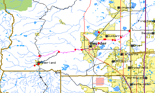
The above map indicates water quality monitoring sites. To view data at a specific site select it from the map with the mouse. | |||||||||||||||||||||||||||||||||||||||||||||
| |||||||||||||||||||||||||||||||||||||||||||||
Preliminary Data - subject to revision | |||||||||||||||||||||||||||||||||||||||||||||
Return to the BASIN water quality catalogReturn to the BASIN environmental data catalog | |||||||||||||||||||||||||||||||||||||||||||||
|
| |||||||||||||||||||||||||||||||||||||||||||||
|
About BASIN | Attribution | Feedback | Search | |||||||||||||||||||||||||||||||||||||||||||||