| |||||||||||||||||||||||||||||||||||||||||||||
 | |||||||||||||||||||||||||||||||||||||||||||||
 Indicates no data available Indicates no data available | |||||||||||||||||||||||||||||||||||||||||||||
 Indicates data exceeds plot scale. Indicates data exceeds plot scale. | |||||||||||||||||||||||||||||||||||||||||||||
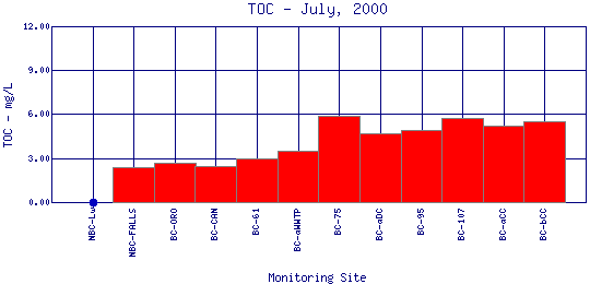
Total Organic Carbon (TOC) Organic matter plays a major role in aquatic systems. It affects biogeochemical processes, nutrient cycling, biological availability,chemical transport and interactions. It also has direct implications in the planning of wastewater treatment and drinking water treatment. Organic matter content is typically measured as total organic carbon and dissolved organic carbon, which are essential components of the carbon cycle. | |||||||||||||||||||||||||||||||||||||||||||||
| |||||||||||||||||||||||||||||||||||||||||||||
|
| |||||||||||||||||||||||||||||||||||||||||||||
| |||||||||||||||||||||||||||||||||||||||||||||
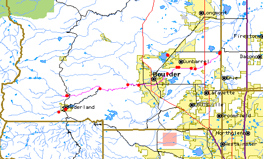
The above map indicates water quality monitoring sites. To view data at a specific site select it from the map with the mouse. | |||||||||||||||||||||||||||||||||||||||||||||
| |||||||||||||||||||||||||||||||||||||||||||||
Preliminary Data - subject to revision | |||||||||||||||||||||||||||||||||||||||||||||
Return to the BASIN water quality catalogReturn to the BASIN environmental data catalog | |||||||||||||||||||||||||||||||||||||||||||||
|
| |||||||||||||||||||||||||||||||||||||||||||||
|
About BASIN | Attribution | Feedback | Search | |||||||||||||||||||||||||||||||||||||||||||||