|
|

|
City of Boulder Storm Water Quality Program |
|
Boulder Creek Watershed
Water Quality Data Time Series for 2005
Boulder Creek at 107th St |
Preliminary Data - subject to revision
|
|
|
|
|
|
|
|
|
|
|
|
|
|
|
|
|
|
|
|
|
|
 Indicates no data available Indicates no data available |  Indicates data exceeds plot scale. Indicates data exceeds plot scale. |
|
|
|
|
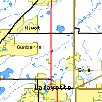
Monitoring site information: |
|

|
- Location: Boulder Creek at 107th St
- Name: BC-107
- Type: Composite
- Frequency: Monthly
- Longitude: 105 ° W 61'
- Latitude: 40 ° N 35'
- Elevation: 5010 feet asl
- Site photo
|
|
| Downstream Site: Boulder Creek Above Coal Creek |
| Upstream Site: Boulder Creek at 95th St |
|
| Plot Label |
Date |
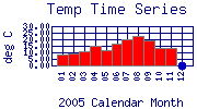
Temp
° C |
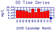
DO
mg/L |
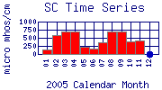
SC
µ mhos/cm |
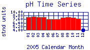
pH
stnd units |
TOC
mg/L |
Flow
cfs |
Alk
mg/L as CaCO3 |
Hard
mg/L as CaCO3 |
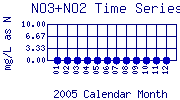
NO3+NO2
mg/L as N |
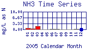
NH3
mg/L as N |
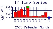
TP
mg/L as P |
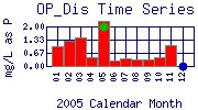
OP_Dis
mg/L as P |
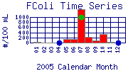
FColi
#/100 mL |
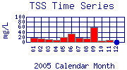
TSS
mg/L |
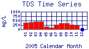
TDS
mg/L |
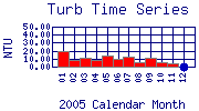
Turb
NTU |
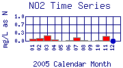
NO2
mg/L as N |
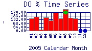
DO%
- |
SampleDate
|
| 01 |
January, 2005 |
8.30 |
11.43 |
131 |
8.41 |
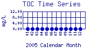
No Data |
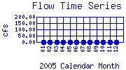
No Data |
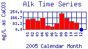
147.0 |
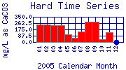
242.0 |
No Data |
0.70 |
1.07 |
0.99 |
40 |
17 |
402 |
19.00 |
0.1 |
111.90 |
No Data |
| 02 |
February, 2005 |
9.00 |
11.77 |
573 |
8.50 |
No Data |
No Data |
151.0 |
240.0 |
No Data |
0.60 |
1.34 |
1.27 |
< 20* |
14 |
406 |
8.30 |
0.1 |
127.80 |
No Data |
| 03 |
March, 2005 |
10.50 |
11.11 |
687 |
8.28 |
No Data |
No Data |
126.0 |
236.0 |
No Data |
2.00 |
1.64 |
1.47 |
< 20* |
12 |
434 |
11.10 |
0.2 |
11.73 |
No Data |
| 04 |
April, 2005 |
15.00 |
10.14 |
698 |
8.32 |
No Data |
No Data |
166.0 |
238.0 |
No Data |
0.10 |
0.49 |
0.47 |
No Data |
8 |
432 |
7.70 |
0.1 |
121.10 |
No Data |
| 05 |
May, 2005 |
11.40 |
8.60 |
233 |
7.66 |
No Data |
No Data |
57.0 |
106.0 |
No Data |
< 0.10* |
2.20 |
2.26 |
140 |
19 |
166 |
13.20 |
0.0* |
95.10 |
No Data |
| 06 |
June, 2005 |
16.40 |
13.65 |
164 |
7.68 |
No Data |
No Data |
43.0 |
62.0 |
No Data |
0.30 |
0.23 |
0.28 |
140 |
32 |
120 |
10.10 |
0.0* |
166.70 |
No Data |
| 07 |
July, 2005 |
20.00 |
9.06 |
360 |
7.64 |
No Data |
No Data |
88.0 |
144.0 |
No Data |
0.40 |
0.32 |
0.37 |
1300 |
17 |
282 |
12.00 |
0.1 |
115.00 |
No Data |
| 08 |
August, 2005 |
22.70 |
14.02 |
705 |
8.21 |
No Data |
No Data |
231.0 |
284.0 |
No Data |
0.09* |
0.30 |
0.35 |
210 |
13 |
358 |
5.99 |
0.0* |
197.20 |
No Data |
| 09 |
September, 2005 |
19.20 |
9.21 |
691 |
8.32 |
No Data |
No Data |
158.0 |
278.0 |
No Data |
< 0.10* |
0.21 |
0.32 |
90 |
58 |
370 |
11.40 |
0.0* |
117.80 |
No Data |
| 10 |
October, 2005 |
13.00 |
10.30 |
387 |
8.17 |
No Data |
No Data |
119.0 |
42.0 |
No Data |
0.10 |
0.44 |
0.46 |
330 |
6 |
278 |
6.10 |
0.0* |
113.50 |
No Data |
| 11 |
November, 2005 |
13.10 |
11.28 |
404 |
7.87 |
No Data |
No Data |
98.0 |
136.0 |
No Data |
0.20 |
1.01 |
1.07 |
40 |
7 |
228 |
4.60 |
0.2 |
No Data |
No Data |
| 12 |
December, 2005 |
No Data |
No Data |
No Data |
No Data |
No Data |
No Data |
No Data |
No Data |
No Data |
No Data |
No Data |
No Data |
No Data |
No Data |
No Data |
No Data |
No Data |
No Data |
No Data |
| * indicates measured value below analysis detection limit listed below: |
|---|
| Lower Detection Limit |
0.0 | | 1.0 | NA | | | 1.0 | 0.1 | 0.1 | 0.1 | 0.03 | 0.03 | 20.0 | 1 | 1 | 0.01 | 0.001 | | |
|---|
|
Preliminary Data - subject to revision
|
|
Select on the parameter name to view more detailed information on that parameter at this station.
Select on the table date to view stream data profiles observed on that date.
|
INVITATION:
BASIN is a community project actively seeking public participation. We
appreciate all feedback and welcome comments, suggestions and contributions.
To find out more about how you can be involved,
click here.
|
|
Home
| Site Map
| Glossary
| Bibliography
| Contributors
About BASIN
| Attribution
| Feedback
| Search
|
