|
|

|
City of Boulder Storm Water Quality Program |
|
Boulder Creek Watershed
Water Quality Data Time Series for 2008
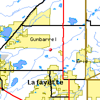
Boulder Creek at 95th St |
Preliminary Data - subject to revision
|
|
|
|
|
|
|
|
|
|
|
|
|
|
|
|
|
|
|
|
|
|
|
|
|
 Indicates no data available Indicates no data available |  Indicates data exceeds plot scale. Indicates data exceeds plot scale. |
|
|
|
|
Monitoring site information: |
|

|
- Location: Boulder Creek at 95th St
- Name: BC-95
- Type: Composite
- Frequency: Monthly
- Longitude: 105 ° W 78'
- Latitude: 40 ° N 28'
- Elevation: 5050 feet asl
- Site photo
|
|
| Downstream Site: Boulder Creek at 107th St |
| Upstream Site: Boulder Creek above Dry Creek |
|
| Plot Label |
Date |
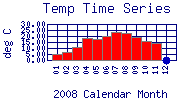
Temp
° C |
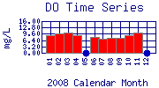
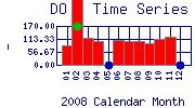
DO
mg/L |
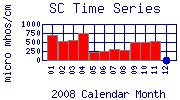
SC
µ mhos/cm |
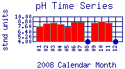
pH
stnd units |
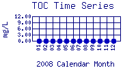
TOC
mg/L |
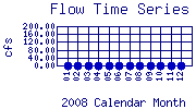
Flow
cfs |
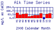
Alk
mg/L as CaCO3 |
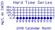
Hard
mg/L as CaCO3 |
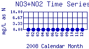
NO3+NO2
mg/L as N |
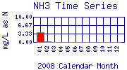
NH3
mg/L as N |
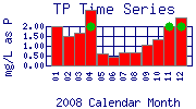
TP
mg/L as P |
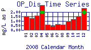
OP_Dis
mg/L as P |
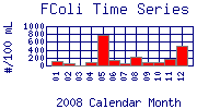
FColi
#/100 mL |
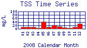
TSS
mg/L |
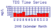
TDS
mg/L |
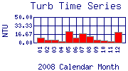
Turb
NTU |
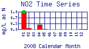
NO2
mg/L as N |
DO%
- |
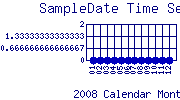
SampleDate
|
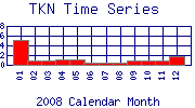
TKN
|
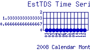
EstTDS
|
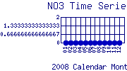
NO3
|
| 01 |
January, 2008 |
5.00 |
8.74 |
695 |
7.70 |
No Data |
No Data |
122.0 |
No Data |
No Data |
3.90 |
1.98 |
1.56 |
110 |
11 |
416 |
9.09 |
1.0 |
87.30 |
No Data |
|
No Data |
No Data |
| 02 |
February, 2008 |
6.80 |
9.65 |
531 |
8.32 |
No Data |
No Data |
84.0 |
No Data |
No Data |
0.40 |
1.48 |
1.31 |
50 |
10 |
332 |
5.14 |
0.1 |
937.00 |
No Data |
|
No Data |
No Data |
| 03 |
March, 2008 |
11.20 |
10.24 |
566 |
8.57 |
No Data |
No Data |
96.0 |
No Data |
No Data |
< 0.10* |
1.66 |
1.63 |
< 20* |
10 |
360 |
5.16 |
0.0* |
117.10 |
No Data |
|
No Data |
No Data |
| 04 |
April, 2008 |
18.30 |
8.95 |
763 |
8.10 |
No Data |
No Data |
106.0 |
No Data |
No Data |
< 0.10* |
2.85 |
2.75 |
70 |
5 |
490 |
3.10 |
0.3 |
102.90 |
No Data |
|
No Data |
No Data |
| 05 |
May, 2008 |
17.80 |
No Data |
234 |
7.58 |
No Data |
No Data |
45.0 |
No Data |
No Data |
< 0.10* |
0.61 |
0.59 |
790 |
43 |
142 |
22.10 |
0.0* |
No Data |
No Data |
|
No Data |
No Data |
| 06 |
June, 2008 |
20.40 |
7.98 |
259 |
8.70 |
No Data |
No Data |
58.0 |
No Data |
No Data |
< 0.10* |
0.45 |
0.45 |
130 |
10 |
164 |
9.35 |
0.0* |
107.20 |
No Data |
|
No Data |
No Data |
| 07 |
July, 2008 |
23.70 |
6.98 |
301 |
8.73 |
No Data |
No Data |
71.0 |
No Data |
No Data |
< 0.10* |
0.68 |
0.67 |
50 |
21 |
214 |
18.60 |
0.0* |
103.30 |
No Data |
|
No Data |
No Data |
| 08 |
August, 2008 |
22.80 |
7.49 |
282 |
No Data |
No Data |
No Data |
68.0 |
No Data |
No Data |
< 0.10* |
0.68 |
0.61 |
230 |
15 |
198 |
12.50 |
0.0* |
105.70 |
No Data |
|
No Data |
No Data |
| 09 |
September, 2008 |
18.90 |
7.35 |
497 |
8.46 |
No Data |
No Data |
111.0 |
No Data |
No Data |
< 0.10* |
1.07 |
0.99 |
80 |
8 |
356 |
5.94 |
0.0* |
96.80 |
No Data |
|
No Data |
No Data |
| 10 |
October, 2008 |
15.70 |
9.05 |
491 |
8.86 |
No Data |
No Data |
No Data |
No Data |
No Data |
< 0.10* |
1.34 |
1.21 |
80 |
5 |
336 |
4.12 |
0.0* |
111.30 |
No Data |
|
No Data |
No Data |
| 11 |
November, 2008 |
14.40 |
10.18 |
525 |
8.54 |
No Data |
No Data |
100.0 |
No Data |
No Data |
< 0.10* |
2.02 |
1.56 |
170 |
10 |
374 |
2.30 |
0.0* |
122.60 |
No Data |
|
No Data |
No Data |
| 12 |
December, 2008 |
No Data |
No Data |
No Data |
No Data |
No Data |
No Data |
113.0 |
No Data |
No Data |
< 0.10* |
2.46 |
2.46 |
490 |
31 |
400 |
21.00 |
0.0* |
No Data |
No Data |
|
No Data |
No Data |
| * indicates measured value below analysis detection limit listed below: |
|---|
| Lower Detection Limit |
0.0 | | 1.0 | NA | | | 1.0 | 0.1 | 0.1 | 0.1 | 0.03 | 0.03 | 20.0 | 1 | 1 | 0.01 | 0.001 | | | | | |
|---|
| * indicates measured value exceeds plot scale: |
|---|
| Typical Range Ceiling |
30 | 16 | 1000 | 10 | 12.0 | 200 | 250 | 350 | 10 | 10 | 2 | 2 | 1000 | 100 | 1000 | 50 | 1.0 | 170 | | | | |
|---|
|
Preliminary Data - subject to revision
|
|
Select on the parameter name to view more detailed information on that parameter at this station.
Select on the table date to view stream data profiles observed on that date.
|
INVITATION:
BASIN is a community project actively seeking public participation. We
appreciate all feedback and welcome comments, suggestions and contributions.
To find out more about how you can be involved,
click here.
|
|
Home
| Site Map
| Glossary
| Bibliography
| Contributors
About BASIN
| Attribution
| Feedback
| Search
|
