|
|

|
City of Boulder Storm Water Quality Program |
|
Boulder Creek Watershed
Water Quality Data Time Series for 2008
Boulder Creek Below Coal Creek |
Preliminary Data - subject to revision
|
|
|
|
|
|
|
|
|
|
|
|
|
|
|
|
|
|
|
|
|
|
|
|
|
 Indicates no data available Indicates no data available |  Indicates data exceeds plot scale. Indicates data exceeds plot scale. |
|
|
|
|
Monitoring site information: |
|

|
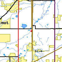
- Location: Boulder Creek Below Coal Creek
- Name: BC-bCC
- Type: Composite
- Frequency: Monthly
- Longitude: 105 ° W 34'
- Latitude: 40 ° N 50'
- Elevation: 4955 feet asl
- Site photo
|
|
| Downstream Site: North Boulder Creek diversion to Lakewood |
| Upstream Site: Boulder Creek Above Coal Creek |
|
| Plot Label |
Date |
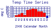
Temp
° C |
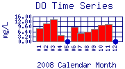
DO
mg/L |
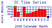
SC
µ mhos/cm |
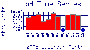
pH
stnd units |
TOC
mg/L |
Flow
cfs |
Alk
mg/L as CaCO3 |
Hard
mg/L as CaCO3 |
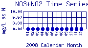
NO3+NO2
mg/L as N |
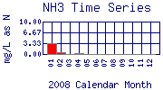
NH3
mg/L as N |
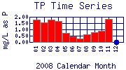
TP
mg/L as P |
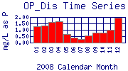
OP_Dis
mg/L as P |
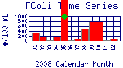
FColi
#/100 mL |
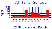
TSS
mg/L |
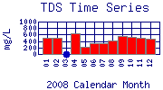
TDS
mg/L |
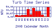
Turb
NTU |
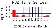
NO2
mg/L as N |
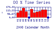
DO%
- |
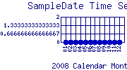
SampleDate
|
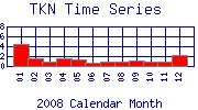
TKN
|
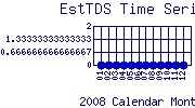
EstTDS
|
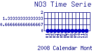
NO3
|
| 01 |
January, 2008 |
4.90 |
8.54 |
1088 |
8.11 |
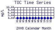
No Data |
No Data |
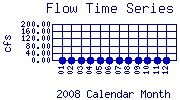
180.0 |
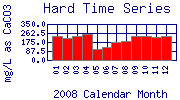
234.0 |
No Data |
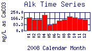
3.30 |
1.76 |
1.30 |
330 |
18 |
496 |
10.30 |
0.7 |
81.80 |
No Data |
|
No Data |
No Data |
| 02 |
February, 2008 |
7.70 |
11.52 |
460 |
8.74 |
No Data |
No Data |
153.0 |
218.0 |
No Data |
0.60 |
1.56 |
1.34 |
170 |
11 |
500 |
6.39 |
0.1 |
112.30 |
No Data |
|
No Data |
No Data |
| 03 |
March, 2008 |
11.30 |
14.12 |
8 |
9.14 |
No Data |
No Data |
156.0 |
232.0 |
No Data |
< 0.10* |
1.77 |
1.63 |
20 |
12 |
No Data |
9.55 |
0.0* |
157.00 |
No Data |
|
No Data |
No Data |
| 04 |
April, 2008 |
5.80 |
4.06 |
963 |
6.84 |
No Data |
No Data |
217.0 |
256.0 |
No Data |
0.40 |
1.67 |
1.65 |
170 |
14 |
630 |
9.36 |
0.2 |
98.80 |
No Data |
|
No Data |
No Data |
| 05 |
May, 2008 |
21.20 |
No Data |
361 |
7.48 |
No Data |
No Data |
79.0 |
110.0 |
No Data |
< 0.10* |
0.72 |
0.65 |
2200 |
74 |
218 |
39.00 |
0.0* |
No Data |
No Data |
|
No Data |
No Data |
| 06 |
June, 2008 |
22.70 |
9.20 |
377 |
9.55 |
No Data |
No Data |
100.0 |
126.0 |
No Data |
< 0.10* |
0.44 |
0.40 |
20 |
12 |
334 |
12.60 |
0.0* |
138.70 |
No Data |
|
No Data |
No Data |
| 07 |
July, 2008 |
24.90 |
5.42 |
511 |
8.43 |
No Data |
No Data |
137.0 |
172.0 |
No Data |
< 0.10* |
0.29 |
0.26 |
80 |
55 |
338 |
44.70 |
0.0* |
80.30 |
No Data |
|
No Data |
No Data |
| 08 |
August, 2008 |
23.40 |
6.35 |
614 |
No Data |
No Data |
No Data |
151.0 |
184.0 |
No Data |
< 0.10* |
0.60 |
0.58 |
490 |
34 |
426 |
29.00 |
0.0* |
92.10 |
No Data |
|
No Data |
No Data |
| 09 |
September, 2008 |
17.00 |
7.91 |
806 |
8.96 |
No Data |
No Data |
195.0 |
236.0 |
No Data |
< 0.10* |
0.76 |
0.77 |
790 |
38 |
564 |
29.70 |
0.0* |
102.80 |
No Data |
|
No Data |
No Data |
| 10 |
October, 2008 |
16.50 |
10.69 |
783 |
9.16 |
No Data |
No Data |
179.0 |
232.0 |
No Data |
< 0.10* |
0.91 |
0.78 |
790 |
14 |
518 |
11.10 |
0.0* |
129.50 |
No Data |
|
No Data |
No Data |
| 11 |
November, 2008 |
12.50 |
11.07 |
735 |
8.85 |
No Data |
No Data |
159.0 |
226.0 |
No Data |
< 0.10* |
1.82 |
0.98 |
40 |
12 |
512 |
3.00 |
0.1 |
126.80 |
No Data |
|
No Data |
No Data |
| 12 |
December, 2008 |
No Data |
No Data |
No Data |
No Data |
No Data |
No Data |
154.0 |
230.0 |
No Data |
< 0.10* |
No Data |
1.92 |
90 |
76 |
482 |
48.30 |
0.1 |
No Data |
No Data |
|
No Data |
No Data |
| * indicates measured value below analysis detection limit listed below: |
|---|
| Lower Detection Limit |
0.0 | | 1.0 | NA | | | 1.0 | 0.1 | 0.1 | 0.1 | 0.03 | 0.03 | 20.0 | 1 | 1 | 0.01 | 0.001 | | | | | |
|---|
| * indicates measured value exceeds plot scale: |
|---|
| Typical Range Ceiling |
30 | 16 | 1000 | 10 | 12.0 | 200 | 250 | 350 | 10 | 10 | 2 | 2 | 1000 | 100 | 1000 | 50 | 1.0 | 170 | | | | |
|---|
|
Preliminary Data - subject to revision
|
|
Select on the parameter name to view more detailed information on that parameter at this station.
Select on the table date to view stream data profiles observed on that date.
|
INVITATION:
BASIN is a community project actively seeking public participation. We
appreciate all feedback and welcome comments, suggestions and contributions.
To find out more about how you can be involved,
click here.
|
|
Home
| Site Map
| Glossary
| Bibliography
| Contributors
About BASIN
| Attribution
| Feedback
| Search
|
