Excerpts
from Joanna Sampson's digital book
Excerpts
from Joanna Sampson's digital book|
HIGH, WILD AND HANDSOME
The Story of Colorado's Beautiful South Boulder Creek and Eldorado Canyon
Excerpts
from Joanna Sampson's digital bookAvailable online at 1st Books
|
Copyright 2000. All rights reserved.
The famous panorama of snow-capped mountains soaring above miles of dry-land prairie also tells an accurate story of water in Colorado. Those mountains, glistening white against the sky, store huge supplies of water in their snow pack. Brown plains in the foreground go thirsty without irrigation. In a semi-arid state that receives only an average of 15.5 inches annual precipitation, the mountains provide almost all the water for parched prairies and water-guzzling cities. Denver pioneers recognized the need for adequate water supplies because they soon realized that growth of the city and the success of agriculture on the plains depended on a reliable water source. In 1870 the Denver City Water Company was formed to provide a steady, year-round water supply for its customers.
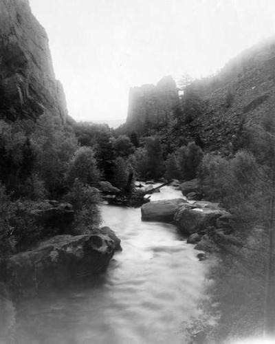
South Boulder Creek was then targeted as the drainage to be used for transporting Western Slope water to the Eastern Slope at the same time the Moffat Tunnel was built. Moffat Tunnel plans for the railroad included a water tunnel parallel to the main bore. Colorado's mountain snow pack melts quickly in the spring. This huge seasonal flood requires storage if it is to be used for year-round consumption. The Diversion Dam was built on South Boulder Creek several miles above Eldorado Springs. This dam was one of the largest in the state at the time of its construction. Excavation for the Diversion Dam was begun on August 3, 1935. The rest of the water project was well described by Ralph Radetsky,
reporter for the Boulder Daily Camera on January 5, 1936: "There
is still, however, plenty to do east of the dam. You've got to build conduits,
a series of five tunnels, six siphons and six flumes, to take water from
the dam to Ralston Creek. Then on Ralston Creek you've got to build a
huge reservoir dam." When use of the water from the Moffat Pioneer Bore began, the raw water from the Western Slope was considered the finest quality water ever made available for use by Denver. Gross Reservoir holds over 40,000 acre feet of water and as Boulder Daily Camera reporter Barbara Kossler noted in 1960, "When the water cascades in a frothy meringue over the 160 feet of spillway, it is more than impressive, practical, utilitarian...it is beautiful." The current license for the Gross Reservoir project expired May 1, 2000. Projected life for Gross Dam is estimated at 1000 years. Major threats to its longevity are: a) an earthquake along the Golden fault (which is not an active fault at the present time), b) a huge "Noah" type flood that could seep under the dam and tip it over, c) neglect, d) a terrorist attack. Even though none of the above failures or disasters is anticipated, Denver Water, Boulder County Emergency Management along with Boulder Sheriff Emergency Services and the Eldorado Springs-Marshall Fire Department have emergency plans and warning systems in place in case the integrity of the dam is ever threatened. Excerpts from Chapter Four, Eldorado Springs Resort In 1938 a major flood hit the community. Heavy rains and hail storms battered the state during August causing widespread damage and evacuation of homes on the Front Range. At 7 p.m. on September 2, a wall of water hit Eldorado Canyon and raged all night. Houses, the pavilion, bath house, dance hall and all roads and bridges were washed out. Residents fled to high ground on either side of the creek and spent a wet, terrifying night in the open. E.E. Sullivan and R.A. Stokely, members of the Matt Betton orchestra from the University of Kansas, had been playing at the resort for five weeks prior to the flood. "The lights went out about 7 o'clock", Stokely told a reporter the next day, "and soon after that we heard the crashing of the Arcade. We rushed to the dance hall and managed to save two instruments though warned against going into the building." The orchestra lost a library of music valued at $1000 along with all the instruments except the two saxophones they retrieved the night before. Tim Shanahan, whose family homesteaded some of the first land in Boulder County, remembers, "the morning after the flood, musical instruments and slot machines were scattered all along the fields east of our ranch." The South Boulder Creek flood plain includes much of the land east of the Shanahan ranch that lies directly south of the Boulder city limits on Highway 93. Most of the present University of Colorado-owned "Flatiron" property is flood plain. That land was all under water during the flood in 1938. See Photos
of Eldorado Canyon and 1938 Flood of Eldorado Springs |