The amount of land annexed over time is
a measure of a region's growth and land-use. In other words, it is a
measure of urbanization. The debate about growth and growth management
is one of the predominant topics on Boulder County's public agenda.
Recently, the Boulder County Commissioners issued a newsletter called
Growth Watch which documents trends in population growth, projects
population estimates out to 2010 and presents the impacts of this growth
on housing, transportation and the schools. Land Annexation, by Boulder County
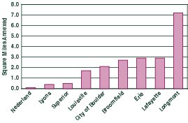
Municipalities (1984-1997 Combined) Total land area annexed in Boulder County since 1984 equals roughly 20 square miles or about 13,000 acres. This represents a land area larger than Longmont and Niwot combined. Longmont has annexed by far the most land over the past fifteen years, increasing its size by almost forty percent. The bulk of Superior's acreage was annexed in 1987, with the addition of over 1,000 acres for the Rock Creek development. Longmont added large portions to itself in 1994, 1995, and 1997, while annexation in Boulder, Broomfield and Lafayette tapered off in those years. Based on these trends, future projections can be made about the growth and development in Boulder County. According to Growth Watch, Boulder county is slated for continuing population growth, which will be accompanied by a great deal more development, requiring enormous investments in roads, water, sewer systems, schools and other infrastructure. Boulder County must face these questions as a regions and as a community, because it has become clear that each municipality's land-use decisions affect all of us. Table
of Contents/ Overview/Boulder
County at a Glance/A Vision for the Environment
/ |

