 |
|
Barker Dam and Reservoir, Nederland, Colorado
On March 7th 2001 the City of Boulder completed purchase of the Barker Dam and Reservoir system from the Public Service Company of Colorado. The City's Public Works Department is currently developing a management plan in consultation with area residents.
Official news regarding development of this management plan will be provided on the City of Boulders official Barker Reservoir www site.
One change being proposed by the group Boating on Barker (aka BOB) would allow non-motorized boating on the reservoir.
General information about Barker Reservoir and its history is provided below.
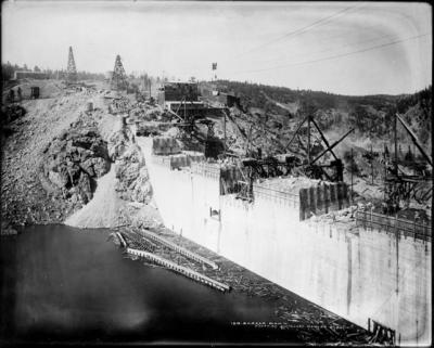
 Construction of the dam at Barker Reservoir on Middle Boulder Creek began in 1909 by the Central Colorado Power Company (later the Public Service Company of Colorado) to provide a new hydroelectric power source for the area. More than 133,000 cubic feet of reinforced concrete were reportedly used to build the 624-foot dam, which was about 120 feet thick at the base and about 16 feet at the top. The dam, which was originally called Nederland Dam, was opened in 1910 (Library of Congress American Memory web page). The dam was constructed on a ranch site previously owned by Hannah Barker.
Water in Barker Reservoir is diverted for both drinking water supply and hydroelectric power. Water is delivered from Barker Reservoir to Boulder Canyon Hydroelectric Power Plant at Orodell via the 11-mile Barker gravity line ( New Century Energies web site). The Barker line also carries water to the City of Boulder's Betasso Water Treatment Plant. Barker Reservoir has been a key component of Boulder's water system since 1954, delivering up to 40 percent of the city's annual water supply. According to the City of Boulder's Raw Water Master Plan, the average flow of Middle Boulder Creek downstream of Barker Reservoir has decreased from about 55 cubic feet per second (CFS) to less than 25 CFS as a result of the reservoir's operations.
Barker Dam regulates some storm water runoff into Middle Boulder Creek but it has no effect on North Boulder Creek or on Four Mile Creek, which joins Middle Boulder Creek a few miles up the canyon from Boulder.
In 2001 the city of Boulder purchased the Boulder Canyon Hydroelectric Project from Xcel Energy, formerly Public Service Company of Colorado. The purchase includes Barker and Kossler reservoirs as well as the connecting pipelines, rights-of-way and the Boulder Canyon Hydroelectric Plant. Boulder will take over the operation and maintenance of Barker Reservoir and the Boulder Canyon Hydroelectric Plant.
Water quality data for Middle Boulder Creek just upstream of Barker Reservoir can be found at the BASIN water quality page for Boulder Creek (see Middle Boulder Creek at PSCo Weir). The U.S. Geological Survey stream gage on Middle Boulder Creek can be reached at http://bcn.boulder.co.us/basin/watershed/hydrograph.html. For more information on the City of Boulder's water supply, see The City of Boulder's Public Works website. Also see a map of Boulder's sources for drinking water.
For more information on Barker Dam and Reservoir and Middle Boulder Creek:
General Boulder Creek Information: http://bcn.boulder.co.us/basin/watershed/boulder.html
Boulder Water Supply Story: http://bcn.boulder.co.us/basin/learning/supply.html
Floods in the Boulder Creek Watershed: http://bcn.boulder.co.us/basin/watershed/flooding.html
Historic photos of Barker Dam and the surrounding area:
http://bcn.boulder.co.us/basin/gallery/barkerdam.html
http://bcn.boulder.co.us/basin/gallery/barkersouth.html
http://bcn.boulder.co.us/basin/gallery/barkerearly.html
http://bcn.boulder.co.us/basin/gallery/barkermeadow.html
http://bcn.boulder.co.us/basin/gallery/nearned.html
http://bcn.boulder.co.us/basin/gallery/nedjackson.html
http://bcn.boulder.co.us/basin/gallery/bouldercanyon.html
Library of Congress American Memory, History of the American West, 1860-1920: Photographs from the Collection of the Denver Public Library. http://memory.loc.gov/ammem/award97/codhtml/hawpSubjects88.html
Documents containing more information on the Barker Reservoir area can be obtained at local libraries. The BASIN bibliography contains information about the following documents:
Robinson, Charles S.; Moss, Allan S.E.; and Robinson Charles H. Stabilization, Barker Dam, Colorado, USA.
Becker, Isabel M. Nederland: a Trip to Cloudland.
Gable, Dolores J. Geologic Map of the Nederland Quadrangle, Boulder and Gilpin Counties, Colorado.
U.S. Geological Survey Geology. Nederland and Vicinity, Colorado [map].
References
Heaney, James P.; Wright, Len; and Sample, David Sample (1999). Urban Stormwater and Watershed Management: A Case Study. Chapter 9. In Innovative Urban Wet-Weather Flow Management Systems.
http://www.epa.gov/ednnrmrl/publish/book/epa-600-r-99-029/achap09.pdfLibrary of Congress American Memory. History of the American West, 1860-1920: Photographs from the Collection of the Denver Public Library. http://memory.loc.gov/ammem/award97/codhtml/hawpSubjects88.html
New Century Energies web site. http://www.psco.com/Operations/PowerPlantItem.ASP?NUMBER=21