
Homepage - Brochure - Application - Newsletters - Archives - Links - Weather - Board
BATCO has filed the following application for updates to the 2005 Boulder Valley Comprehensive Plan
We request that the Boulder Valley Comprehensive Plan Trails Map be updated to reflect the trail priorities identified in recent Boulder City and County trails planning activities.
Since the last update to the Boulder Valley Comprehensive Plan Trails Map, the City of Boulder Open Space and Mountain Parks Department has been through a series of planning activities that have resulted in the identification of a number of priority future trails and connections:
Following the passage of a countywide transportation improvement sales and use tax in the November 2001 election, the Boulder County Commissioners created the Boulder County Regional Trails Committee to set priorities and objectives for regional trail planning and development over the next seven years. During 2002, the Committee held a series of public meetings that led to the creation of a list of Regional Trail Priorities (See Attachment 5). In April 2003, the County Commissioners approved the Regional Trail Priorities.
Additional support for two of the major regional trails, the Feeder Canal Trail and the Union Pacific Railroad Trail is included in Attachment 6.
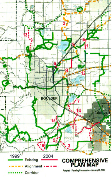
We request that this update to the Boulder Valley Comprehensive Plan incorporate a revised Trails Map that includes all the priority trails identified in the referenced sources that are within the scope of the plan. To facilitate this process, we summarize the results of the recent planning activities and include a list of the trails and a correspondingly revised version of the 1999 Boulder Valley Comprehensive Plan Trails Map.
The following list itemizes trails from the attachments that are within the Boulder Valley Comprehensive Plan planning area (parenthesized lists indicate which of the Attachments reference the associated trail).
We show these trails on a revised version of the Boulder Valley Comprehensive Plan Trails Map. We show new or changed alignments in red. We number the map entries (in red) to correspond to the above list. When a priority trail is already included on the 1999 Trails Map we keep the 1999 color-coding and number the trail in red. In past updates to the Comprehensive Plan previously identified trails have been removed for the updated map. In additional to requesting the modifications we list, we request that all the priority trails listed above and previously included on the 1999 Trails Map continue to be included on the revised map.
Link to high resolution map image
Additional References:
BATCO & OSMP Trails Discussions
County Comprehensive Plan Trails Map