|
What is a Watershed Address?
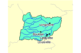
Image from the EPA Surf Your Watershed Site |
Boulder Creek and its tributaries flow
into the St. Vrain River, which joins the South Platte, becoming the
Platte, then the Missouri, which flows into the Mississippi, and finally
into the Gulf of Mexico and the Caribbean and Atlantic oceans. |
Your watershed address shows the connections
between all the rivers downstream of a particular location. If
you were in New Orleans and needed returned home following the
rivers, you would backtrack this route. Knowing your watershed
address is helpful in terms of understanding what is upstream
and downstream, which can be an important consideration in terms
of preventing pollution or preparing for potential flash floods.
Also see "National Watershed Units"
and "What is a Watershed Address?"
|
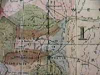
Can you find the St. Vrain Watershed on this USGS map?
Click on image for larger map of the entire
Missouri River Basin. |
|
|
Through the "great round river" of the
hydrologic cycles, all water is ultimately connected back to its
original source in the ocean. Waters that flow downstream sooner
or later (sometimes after many side diversions) return to the ocean,
although perhaps a different one from where the particular molecules
evaporated into the atmosphere.
|
|