| |||||||||||||||||||||||||||||||||||||||||||||||||||||||||
 | |||||||||||||||||||||||||||||||||||||||||||||||||||||||||
 Indicates no data available Indicates no data available | |||||||||||||||||||||||||||||||||||||||||||||||||||||||||
 Indicates data exceeds plot scale. Indicates data exceeds plot scale. | |||||||||||||||||||||||||||||||||||||||||||||||||||||||||
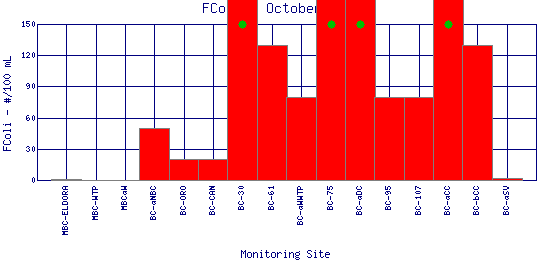
Fecal Coliform Bacteria is found in the intestinal tracts of mammals. High concentrations of the bacteria in water or sludge suggest the presence of disease-causing organisms, and may be caused by septic tank failure, poor pasture and animal keeping practices, pet waste, and urban runoff. To measure fecal coliform bacteria, water samples are collected in sterilized containers, filtered, and incubated at a certain temperature. The resulting bacterial colonies that form are counted and recorded as the number of colony producing units per 100 ml of water (CPU/100 ml). Safe drinking water should have fecal coliform counts of 0 CPU/100 ml. For safe swimming, concentrations less than 200 CPU/100 ml is desirable, and for boating, less than 1000 CPU/100 ml is desirable. However, these standards may vary at the local, state, and federal level. | |||||||||||||||||||||||||||||||||||||||||||||||||||||||||
| |||||||||||||||||||||||||||||||||||||||||||||||||||||||||
|
| |||||||||||||||||||||||||||||||||||||||||||||||||||||||||
| |||||||||||||||||||||||||||||||||||||||||||||||||||||||||
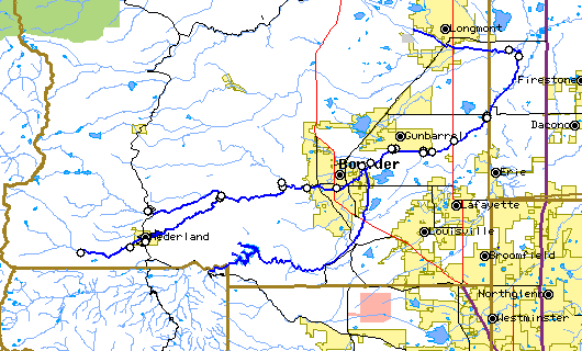
The above map indicates water quality monitoring sites. To view data at a specific site select it from the map with the mouse. | |||||||||||||||||||||||||||||||||||||||||||||||||||||||||
| |||||||||||||||||||||||||||||||||||||||||||||||||||||||||
Preliminary Data - subject to revision | |||||||||||||||||||||||||||||||||||||||||||||||||||||||||
Return to the BASIN water quality catalogReturn to the BASIN environmental data catalog | |||||||||||||||||||||||||||||||||||||||||||||||||||||||||
|
| |||||||||||||||||||||||||||||||||||||||||||||||||||||||||
|
About BASIN | Attribution | Feedback | Search | |||||||||||||||||||||||||||||||||||||||||||||||||||||||||