|
|

|
City of Longmont Water Quality Monitoring |
|
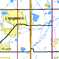
Saint Vrain Watershed
Water Quality Data Time Series for 2000
St. Vrain River at County Line Road |
Preliminary Data - subject to revision
|
|
|
|
|
|
|
|
|
|
|
|
|
|
|
|
|
|
|
|
 Indicates no data available Indicates no data available |  Indicates data exceeds plot scale. Indicates data exceeds plot scale. |
|
|
|
|
Monitoring site information: |
|
- Location: St. Vrain River at County Line Road
- Name: SVaCL
- Type: Unknown
- Frequency: Unknown
- Longitude: 105 ° W 35'
- Latitude: 40 ° N 89'
- Elevation: feet asl
|
|
| Downstream Site: St. Vrain River at Boulder Creek |
| Upstream Site: St. Vrain River above WWTP Effluent |
|
| Plot Label |
Date |
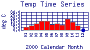
Temp
° C |
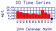
DO
mg/L |
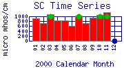
SC
µ mhos/cm |
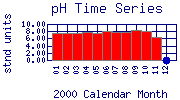
pH
stnd units |
TOC
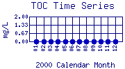
mg/L |
Flow
cfs |
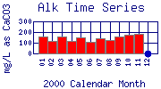
Alk
mg/L as CaCO3 |
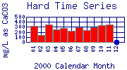
Hard
mg/L as CaCO3 |
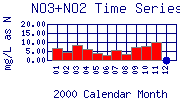
NO3+NO2
mg/L as N |
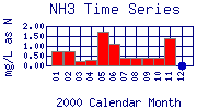
NH3
mg/L as N |
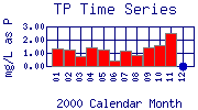
TP
mg/L as P |
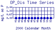
OP_Dis
mg/L as P |
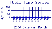
FColi
#/100 mL |
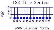
TSS
mg/L |
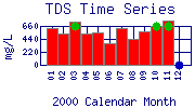
TDS
mg/L |
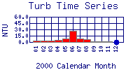
Turb
NTU |
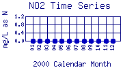
NO2
mg/L as N |
| 01 |
January, 2000 |
5.0 |
13.20 |
920 |
7.43 |
No Data |
46.36 |
157 |
320 |
6.50 |
0.70 |
1.30 |
No Data |
No Data |
No Data |
632 |
4.0 |
No Data |
| 02 |
February, 2000 |
7.9 |
11.70 |
736 |
7.59 |
No Data |
52.56 |
120 |
144 |
4.42 |
0.70 |
1.24 |
No Data |
No Data |
No Data |
532 |
3.3 |
No Data |
| 03 |
March, 2000 |
10.6 |
9.60 |
1093 |
7.54 |
No Data |
33.22 |
157 |
354 |
8.33 |
0.20 |
0.73 |
No Data |
No Data |
No Data |
730 |
2.5 |
No Data |
| 04 |
April, 2000 |
14.6 |
10.20 |
839 |
7.89 |
No Data |
49.68 |
115 |
248 |
6.20 |
0.30 |
1.41 |
No Data |
No Data |
No Data |
526 |
5.5 |
No Data |
| 05 |
May, 2000 |
14.8 |
8.10 |
821 |
7.56 |
No Data |
51.02 |
147 |
271 |
3.90 |
1.70 |
1.21 |
No Data |
No Data |
No Data |
550 |
8.2 |
No Data |
| 06 |
June, 2000 |
8.8 |
8.70 |
610 |
8.00 |
No Data |
162.23 |
112 |
217 |
2.60 |
1.10 |
0.41 |
No Data |
No Data |
No Data |
374 |
27.0 |
No Data |
| 07 |
July, 2000 |
10.9 |
8.20 |
1019 |
7.90 |
No Data |
59.09 |
141 |
289 |
5.68 |
0.40 |
1.19 |
No Data |
No Data |
No Data |
624 |
8.9 |
No Data |
| 08 |
August, 2000 |
8.1 |
7.90 |
719 |
7.67 |
No Data |
0.00 |
127 |
231 |
3.51 |
0.40 |
0.84 |
No Data |
No Data |
No Data |
448 |
6.3 |
No Data |
| 09 |
September, 2000 |
18.1 |
15.50 |
933 |
8.42 |
No Data |
0.00 |
159 |
287 |
7.45 |
0.40 |
1.45 |
No Data |
No Data |
No Data |
576 |
2.4 |
No Data |
| 10 |
October, 2000 |
13.1 |
11.25 |
1050 |
8.06 |
No Data |
0.00 |
171 |
336 |
7.82 |
0.40 |
1.59 |
No Data |
No Data |
No Data |
664 |
1.5 |
No Data |
| 11 |
November, 2000 |
7.2 |
8.52 |
1180 |
6.47 |
No Data |
37.50 |
187 |
350 |
10.20 |
1.40 |
2.46 |
No Data |
No Data |
No Data |
758 |
1.9 |
No Data |
| 12 |
December, 2000 |
No Data |
No Data |
No Data |
No Data |
No Data |
No Data |
No Data |
No Data |
No Data |
No Data |
No Data |
No Data |
No Data |
No Data |
No Data |
No Data |
No Data |
| * indicates measured value below analysis detection limit listed below: |
|---|
| Lower Detection Limit |
0.0 | | 1.0 | NA | | | 1.0 | 1 | 0.05 | 0.2 | 0.025 | 0.03 | 1.0 | 1 | 1 | 0.01 | 0.001 |
|---|
|
Preliminary Data - subject to revision
|
|
Select on the parameter name to view more detailed information on that parameter at this station.
Select on the table date to view stream data profiles observed on that date.
|
INVITATION:
BASIN is a community project actively seeking public participation. We
appreciate all feedback and welcome comments, suggestions and contributions.
To find out more about how you can be involved,
click here.
|
|
Home
| Site Map
| Glossary
| Bibliography
| Contributors
About BASIN
| Attribution
| Feedback
| Search
|