|
|

|
City of Longmont Water Quality Monitoring |
|
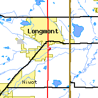
Saint Vrain Watershed
Water Quality Data Time Series for 2000
St. Vrain River above WWTP Effluent |
Preliminary Data - subject to revision
|
|
|
|
|
|
|
|
|
|
|
|
|
|
|
|
|
|
|
|
 Indicates no data available Indicates no data available |  Indicates data exceeds plot scale. Indicates data exceeds plot scale. |
|
|
|
|
Monitoring site information: |
|
- Location: St. Vrain River above WWTP Effluent
- Name: SVaWWTP
- Type: Unknown
- Frequency: Unknown
- Longitude: 105 ° W 59'
- Latitude: 40 ° N 90'
- Elevation: feet asl
|
|
| Downstream Site: St. Vrain River at County Line Road |
| Upstream Site: St. Vrain River at Airport Road |
|
| Plot Label |
Date |
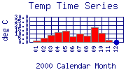
Temp
° C |
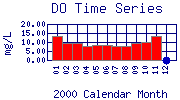
DO
mg/L |
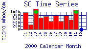
SC
µ mhos/cm |
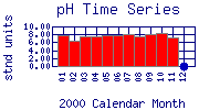
pH
stnd units |
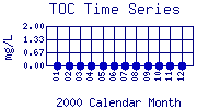
TOC
mg/L |
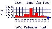
Flow
cfs |
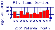
Alk
mg/L as CaCO3 |
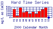
Hard
mg/L as CaCO3 |
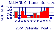
NO3+NO2
mg/L as N |
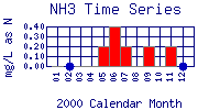
NH3
mg/L as N |
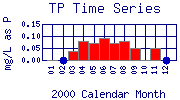
TP
mg/L as P |
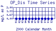
OP_Dis
mg/L as P |
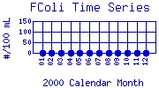
FColi
#/100 mL |
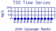
TSS
mg/L |
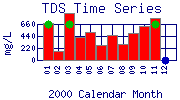
TDS
mg/L |
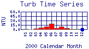
Turb
NTU |
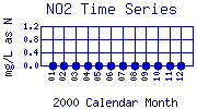
NO2
mg/L as N |
| 01 |
January, 2000 |
2.0 |
13.20 |
971 |
7.75 |
No Data |
17.66 |
183 |
408 |
1.22 |
< 0.20* |
< 0.03* |
No Data |
No Data |
No Data |
684 |
2.4 |
No Data |
| 02 |
February, 2000 |
5.1 |
9.70 |
284 |
6.26 |
No Data |
11.68 |
60 |
80 |
No Data |
No Data |
No Data |
No Data |
No Data |
No Data |
156 |
0.7 |
No Data |
| 03 |
March, 2000 |
8.3 |
9.70 |
1179 |
7.52 |
No Data |
9.34 |
196 |
470 |
1.27 |
< 0.20* |
0.04 |
No Data |
No Data |
No Data |
858 |
2.6 |
No Data |
| 04 |
April, 2000 |
11.6 |
8.00 |
662 |
7.47 |
No Data |
26.34 |
103 |
246 |
0.61 |
< 0.20* |
0.08 |
No Data |
No Data |
No Data |
430 |
5.9 |
No Data |
| 05 |
May, 2000 |
13.5 |
8.30 |
762 |
7.79 |
No Data |
23.89 |
157 |
295 |
0.13 |
0.20 |
0.07 |
No Data |
No Data |
No Data |
510 |
10.1 |
No Data |
| 06 |
June, 2000 |
6.9 |
8.40 |
467 |
7.77 |
No Data |
71.60 |
108 |
185 |
0.47 |
0.40 |
0.09 |
No Data |
No Data |
No Data |
278 |
19.5 |
No Data |
| 07 |
July, 2000 |
10.2 |
7.80 |
764 |
7.97 |
No Data |
17.59 |
147 |
283 |
0.90 |
0.20 |
0.07 |
No Data |
No Data |
No Data |
466 |
5.6 |
No Data |
| 08 |
August, 2000 |
7.3 |
7.90 |
483 |
7.50 |
No Data |
38.69 |
106 |
185 |
0.56 |
< 0.20* |
0.08 |
No Data |
No Data |
No Data |
302 |
9.8 |
No Data |
| 09 |
September, 2000 |
17.1 |
9.25 |
775 |
8.19 |
No Data |
13.58 |
169 |
301 |
1.20 |
0.20 |
0.05 |
No Data |
No Data |
No Data |
496 |
4.5 |
No Data |
| 10 |
October, 2000 |
11.1 |
9.85 |
558 |
8.22 |
No Data |
14.99 |
208 |
389 |
1.37 |
< 0.20* |
< 0.03* |
No Data |
No Data |
No Data |
626 |
2.4 |
No Data |
| 11 |
November, 2000 |
2.1 |
13.52 |
1112 |
7.12 |
No Data |
9.25 |
234 |
467 |
1.96 |
0.20 |
0.05 |
No Data |
No Data |
No Data |
770 |
2.1 |
No Data |
| 12 |
December, 2000 |
No Data |
No Data |
No Data |
No Data |
No Data |
No Data |
No Data |
No Data |
No Data |
No Data |
No Data |
No Data |
No Data |
No Data |
No Data |
No Data |
No Data |
| * indicates measured value below analysis detection limit listed below: |
|---|
| Lower Detection Limit |
0.0 | | 1.0 | NA | | | 1.0 | 1 | 0.05 | 0.2 | 0.025 | 0.03 | 1.0 | 1 | 1 | 0.01 | 0.001 |
|---|
|
Preliminary Data - subject to revision
|
|
Select on the parameter name to view more detailed information on that parameter at this station.
Select on the table date to view stream data profiles observed on that date.
|
INVITATION:
BASIN is a community project actively seeking public participation. We
appreciate all feedback and welcome comments, suggestions and contributions.
To find out more about how you can be involved,
click here.
|
|
Home
| Site Map
| Glossary
| Bibliography
| Contributors
About BASIN
| Attribution
| Feedback
| Search
|