|
|

|
City of Boulder Storm Water Quality Program |
|
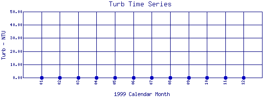
Boulder Creek Watershed
Turbidity Time Series for 1999
Middle Boulder Creek Above North Boulder Creek Confluence |
Preliminary Data - subject to revision
|
|
|
 |
 Indicates no data available Indicates no data available |
 Indicates data exceeds plot scale. Indicates data exceeds plot scale. |
|
|
Information on Turbidity:
Turbidity
is a measure of the cloudiness of the water. Cloudiness is caused by suspended solids or organic matter including silt, microorganisms, plant fibers, sawdust chemicals and coal dust. High levels of turbidity can block light from reaching submerged aquatic vegetation and can raise surface water temperatures because the suspended particles absorb heat from sunlight. The most frequent causes of turbidity are from logging, road and building construction, and mining activity. Turbidity affects fish by decreasing light penetration thus reducing the amount of photosynthesis taking place in the water. This reduces the amount of oxygen available to fish. Large amounts of suspended solids can also clog fish gills, and it affects their ability to see and catch foo
|
|
More general information about Turbidity
|
|
|
Interpretation of Boulder Creek Turbidity data
|
|
|
|
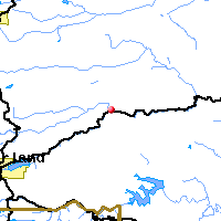
Monitoring site information: |
|

|
- Location: Middle Boulder Creek Above North Boulder Creek Confluence
- Name: BC-aNBC
- Type: Composite
- Frequency: Monthly
- Longitude: 105 ° W 24'
- Latitude: 40 ° N 20'
- Elevation: 6880 feet asl
- Site photo
|
|
| Downstream Site: North Boulder Creek at Boulder Falls |
|
| Plot Label |
Date |
Turb
NTU |
| 01 |
January, 1999 |
No Data |
| 02 |
February, 1999 |
No Data |
| 03 |
March, 1999 |
No Data |
| 04 |
April, 1999 |
No Data |
| 05 |
May, 1999 |
No Data |
| 06 |
June, 1999 |
No Data |
| 07 |
July, 1999 |
No Data |
| 08 |
August, 1999 |
No Data |
| 09 |
September, 1999 |
No Data |
| 10 |
October, 1999 |
No Data |
| 11 |
November, 1999 |
No Data |
| 12 |
December, 1999 |
No Data |
| *value below detection limit: |
|---|
| Detection Limit (if available) |
0.01 |
|---|
|
Preliminary Data - subject to revision
|
|
Select on the parameter name to view all Turbidity time series plots on the basin map.
Select on the table date to view stream Turbidity profiles observed on that date.
Select here to view all parameters at this site.
|
INVITATION:
BASIN is a community project actively seeking public participation. We
appreciate all feedback and welcome comments, suggestions and contributions.
To find out more about how you can be involved,
click here.
|
|
Home
| Site Map
| Glossary
| Bibliography
| Contributors
About BASIN
| Attribution
| Feedback
| Search
|
