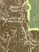
Watershed Address:
Twomile Creek, Goose Creek,
Boulder Creek, St. Vrain, South Platte,
Platte, Missouri, Mississippi, Gulf of Mexico
Approximate length: Four Miles
Description:
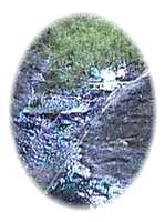
With its headwaters up what is now the Pine Brook
Hills subdivision, Two Mile Creek-- like many small drainages--
is perennial, generally dry through most of its length from July
to March. Between Broadway and Edgewood Twomile Creek is hidden
from view in underground culverts, but where it emerges, just above
the confluence with Goose Creek-- west of Folsom and south of Edgewood--
wild watercress is found.
The 1995 FEMA Flood Insurance Report notes that:
Twomile Creek has frequently overtopped its banks
with silt-laden floodwater. The worst flod on Twomile Creek
occured in September 1933... On August 19, 1965, the Boulder Daily
Camera headline read: "Twomile Canyon Gully Washer Spews Mud Across
Broadway and Into Yards." The article stated that "Water cascading
down normally-dry Twomile Creek spewed mud across sections of Broadway
and silted yards and basements of 8 or 10 homes near Broadway and
Iris Avenue Wednesday afternoon." (p. 14)
Also see 1909 (when
two people were killed in Two Mile Creek), 1941,
1955 and 1969
from History of Flash Floods in BASIN History.
Nearby Neighborhoods (upstream
to downstream)
- Pine Brook Hills
- North Boulder (near Linden & Iris)
Schools
- Foothills Elementary
- Columbine Elementary
Flash Flood Data
Source: FEMA (Federal Emergency Management Association)
June 2, 1995 Flood Insurance Study
|
Flooding Source & Location
|
Drainage Area (Square
Miles)
|
Peak
|
Discharge
|
(CubicFt.
|
per Sec.)
|
|
10-year
|
50-year
|
100-year
|
500-year
|
|
Confluence w/ Goose Creek
|
2.9
|
360
|
840
|
1,120
|
2,000
|
|
Broadway
|
1.68
|
210
|
675
|
890
|
1,800
|
|
Upstream Limit of Study
|
1.40
|
210
|
540
|
710
|
1,430
|
BEYOND BASIN:
It is our intent to build a comprehensive information resource
based on the local watershed theme. One way you can help us develop
this area of the BASIN WWW site is to take
this quick survey. Your input is greatly appreciated.
Do you have a comment or question about this area ? Select
here for a more general BASIN feedback form.
Return to top
|

|
