
|
|
|
modified by Sheila Murphy. Graphics adapted from Runnells by Erica J. Keefe. |
|
|
|
|
modified by Sheila Murphy. Graphics adapted from Runnells by Erica J. Keefe. |
Brief Summary of Boulder Geology
Two great geologic provinces come together in the Boulder area. The eastern province is the Great Plains, ranging from rolling hills to flatlands, and the western province is the Rocky Mountains. The north-south front where the two meet is called the Front Range.
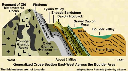
The oldest rocks in the Boulder area have been dated at about 1.7 billion years before present, and are found in the foothills and mountains west of Boulder. About 600 million years ago, ocean water flooded what is now Colorado. For most of the next 300 million years, there was a pattern of gradual flooding by the sea and deposition of sediments, followed by slight uplifts and erosion. None of the rocks deposited during this time period are found near Boulder.
About 300 million years ago, two mountain ranges were pushed up in central and western Colorado. These ranges are known as the Ancestral Rockies. This event pushed the old granitic rocks above the earth's surface; erosion cut into the rocks and carried floods of loose debris away to the east and west. The sea then returned from the east. Over the 150 million years, the Boulder area environment ranged from floodplains, to desert, then to floodplain conditions again, depositing a variety of sedimentary rock types.

About 135 million years ago, sands and gravels were carried eastward over the Boulder area from mountains rising to the west in Utah and Nevada. At about the same time, a massive invasion by the sea began in eastern Colorado. The sea entered the central U.S. from the north and south, laying down a deposit of beach sand along its edge. The next 70 million years were marked by several advances and retreats of the sea. The deposits associated with these episodes of marine flooding consist of shale, sandstone, limestone, and some beds of coal.
About 70 million years ago, the sea slowly withdrew to the northeast, and mountain building began again in Colorado, forming the present Rockies. As the mountains were uplifted, swiftly flowing streams carried floods of debris downward to the plains. Hot magma invaded the older rocks of the mountains, and the forces of mountain building caused the rocks to be greatly deformed. Active mountain building continued throughout the remainder of Tertiary and Quaternary time.
During the past million years or so, there were many active glaciers in the mountains west of Boulder. Glacial deposits and erosional features can be seen in the mountains west of Boulder.
For more detailed geologic history, see the Geologic History of the Boulder Area .
For more information about geology and mining in the Boulder area, see the BASIN bibliography .