|
Preliminary Research Results |
The research done by the University of Colorado’s component of BASIN consists of the following objectives:
- To develop a better understanding of the micro scale rainfall runoff relationship at a small-scale urban site.
- To develop an overall water balance model urban sites, in which the infiltration component is estimated from field data.
The small-scale urban site being used in this study is the Environmental Center for the Rockies (ECR, formerly known as the Land and Water Fund) site at the southwest intersection of Baseline and Broadway in Boulder, Colorado. The following section summarizes the activities at the ECR site.
Environmental Center for the Rockies
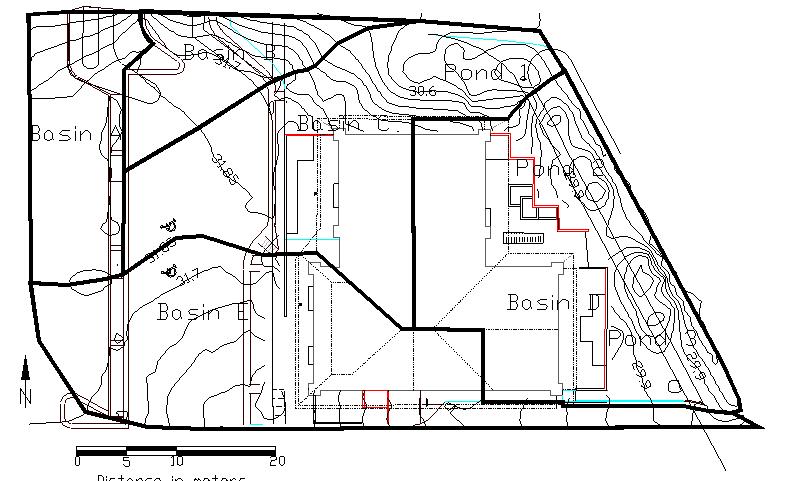
The Environmental Fund of the Rockies site, located at the SW corner of Baseline and Broadway in Boulder, Colorado (see Figure 1) underwent a significant redevelopment several years ago. The owners of the site were committed to the goals of increasing the sustainability of the site by minimizing both the stormwater runoff from the site, and the use of treated water for on-site irrigation purposes. The site was redeveloped to route as much runoff as was possible through a series of three retention ponds. This was done to promote infiltration of roof and parking lot runoff to the greatest extent practical. Due to the extent of impervious surface on the site, it is not practical to capture all of the runoff, but, as can be seen from Figure 1, a portion of the roof and parking lot runoff is directed through the retention ponds before leaving the site, flowing first northward and thence eastward, turning south and exiting the site at the SE corner.
The University of Colorado Dept. of Civil Engineering, Urban Stormwater Group, under the leadership of Dr. Jim Heaney, has been involved in several monitoring and modeling activities at the site. These activities are an attempt to develop a general water budget for the site. A water budget for the site lists all of the water inputs and outputs within a common time frame. Inputs to the site are precipitation, and piped water for indoor use and outdoor irrigation. Outputs are wastewater, stormwater runoff, evapotranspiration, infiltration, and recharge. Precipitation is measured through a rain gage on the site. Indoor water use and outdoor irrigation were measured for a two week period through the use of a data logger and subsequent analysis provided by Aquacraft, Inc. (www.aquacraft.com). Evapotranspiration is modeled based primarily upon temperature, solar radiation, and other climatic data. Temperature is collected at six points throughout the site to capture the heterogeneity of the building’s shadow effect. Wastewater can be inferred through the water supply measurements. Stormwater runoff and infiltration are modeled using appropriate hydrologic models. Recharge can be estimated through the response of the monitoring well that was placed on the NE corner of the site.
Go to Technical Details of this project.

